DriX and FlipiX: Exail’s smart solution for bathymetric, geophysical and UXO surveys
Combining the DriX uncrewed surface vehicle (USV) and the FlipiX remotely operated towed vehicle (ROTV), Exail has developed a unique solution enabling fully autonomous and remotely operated surveys.
Accurate surveys of the seabed are vital before any infrastructure can be installed in the development of maritime projects such as offshore wind farms, cable laying and pipeline installation. DriX is known for being able to accommodate various payloads in its gondola, located two metres below the surface. However, specific projects require higher resolution with sensors carried closer to the seabed.
Leveraging on many years of experience, Exail designed and tested FlipiX, a brand new ROTV, to meet the needs of the offshore industry. This ROTV is perfectly suited to high-resolution bathymetric, geophysical and unexploded ordnance (UXO) surveys in combination with the DriX autonomous surface vessel. With a length of 1.8m and a width of 2.7m, FlipiX is built entirely of composite material. It is a compact and versatile vehicle with active pitch and roll motion stabilization, and can be towed by a USV or a conventional vessel. With its active motion control, FlipiX is perfectly suited to acquiring best-in-class sidescan sonar data at a very high frequency (850kHz), even in the most demanding conditions. 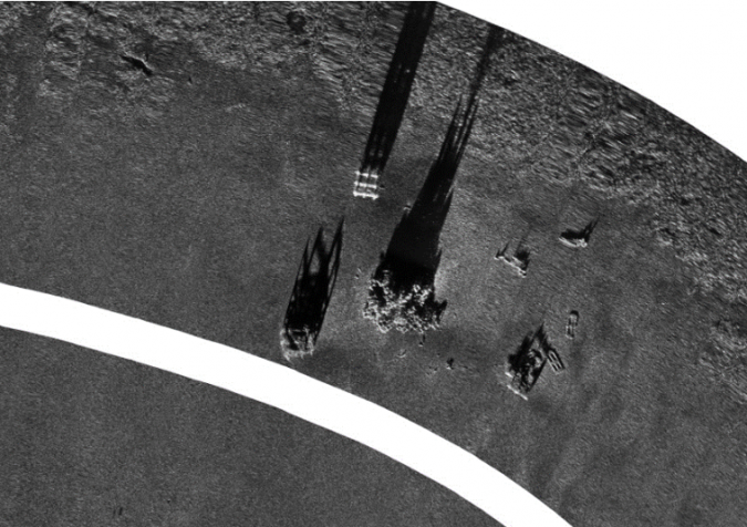
FlipiX can be operated at fixed altitude or fixed depth, down to 100 metres and as close as one metre from the seabed for optimal measurement quality and resolution. From an operator point of view, FlipiX benefits from Exail’s philosophy to design user-friendly human machine interfaces. The ROTV’s control software is directly implemented in DriX’s human machine interface, a web-based interactive system that allows users to easily and efficiently supervise both DriX and FlipiX from the same access point.
From its inception, DriX was designed to be easy to operate, whatever the towing USV’s behaviour. Its positive buoyancy is critical for operational safety. During typical survey patterns, if DriX stops then FlipiX slowly moves upward to the surface, rather than sinking to the bottom like a conventional towed heavyweight payload. As soon as DriX resumes its mission, FlipiX moves back to the requested depth/altitude. DriX and FlipiX can also perform sharp-turn manoeuvres between the survey lines. During turns, FlipiX uses its active motion control to follow and stay at the same depth or altitude. FlipiX’s enhanced stability in turns has a great effect on the survey efficiency.
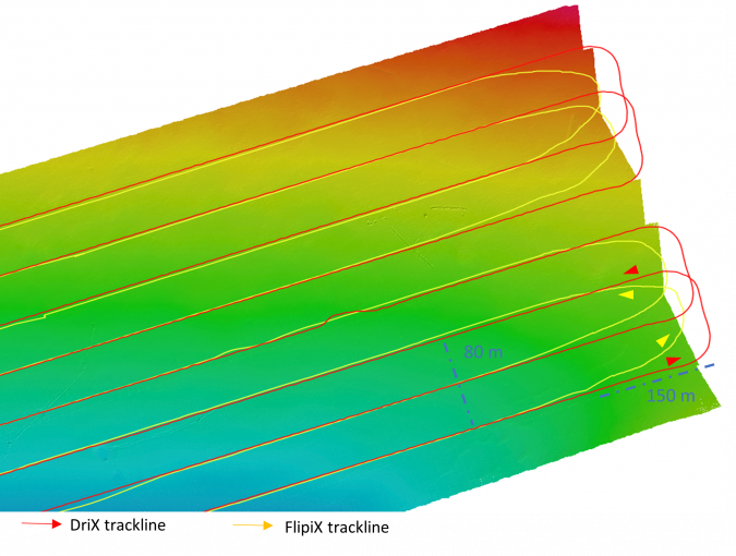
In the example below, FlipiX was towed at 50-metre depth behind DriX using a 120-metre cable to carry out UXO operations. The tracks of both vehicles highlight a sharp and quick 160-metre turn performed in under three minutes, including the 150 metres of run-in before FlipiX is aligned, with a five-metre line offtrack tolerance.
DriX and FlipiX, an outstanding combination for multisensor data acquisition
Owing to an open architecture, DriX and FlipiX can accommodate best-in-class payloads for a wide spectrum of missions. An example configuration is the DriX payload gondola fitted with an Exail Phins Compact C7 inertial navigation system, a multibeam echosounder, an Exail Echoes T1 sub-bottom profiler and an Exail Gaps M5 USBL system.
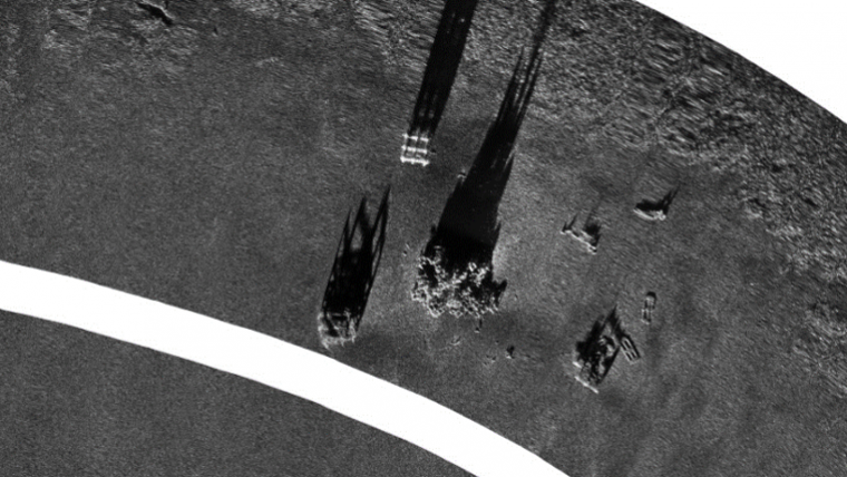
FlipiX is equipped with an EdgeTech 4205 sidescan sonar, a reference in the industry, allowing best-in-class sonar data acquisition up to a frequency of 850Khz. The sidescan sonar provides remarkable imagery data of the seafloor, allowing the inspection of structures, the identification of potential UXO, and seabed and habitat classification. A G882 Caesium Vapour magnetometer from Geometrics was towed 1.5m behind FlipiX. The G882 is a reference for UXO detection projects, being specified for its resolution and detection capabilities. Thanks to its composite material structure and hull, FlipiX provides a low-noise environment. All configurations have shown a maximum of 0.5 nanotesla noise amplitude, meeting the industry requirements for UXO surveys.
A Valeport miniSVS fitted with a pressure sensor allows FlipiX to collect sound velocity profiles during the ROTV’s dive from the surface to the seabed. FlipiX’s real-time underwater position is tracked by an Exail MT9 transponder. The accurate positioning of FlipiX performed by the Gaps USBL and the MT9 beacon allows a direct comparison of the data. This comparison is crucial, especially for UXO surveys, as the combined analysis of MBES, sidescan and magnetometer data makes it possible to determine the anthropic nature of targets found on the seafloor.
One of the main advantages of using DriX and FlipiX together for customers is that the two vehicles provide high-resolution seabed mapping capabilities sailing in a single line at five to six knots and combining multibeam, sub-bottom, sidescan sonar and magnetometer data.
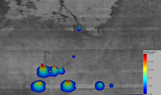
The image below shows the combined results of the sidescan imagery (black and white image) and the 3D representation of the magnetic anomalies (blue to red colours), highlighting the anchor positions of an anchor chain line placed on the seabed.
The use of DriX and FlipiX is the first commercial-grade autonomous solution combining such a comprehensive set of measurements. Exail has also developed a light launch and recovery system that can be installed on RHIBs or small vessels. DriX is designed to be operated over-the-horizon using either 4G or satellite communications, and the availability of high-bandwidth satellite communications such as Starlink is considered a real game-changer in remote survey operations. Data QA/QC can be conducted remotely during the survey, reducing personnel on-site and enhancing operational efficiency. DriX and FlipiX are configured as a standalone integrated package, and all data acquired by FlipiX is recorded in DriX’s survey PC, together with the multibeam, sub-bottom and USBL data. This provides the hydrographic surveyor with an overview of all data in the same hydrographic environment. The image below shows DriX over-the-horizon operation with DriX/FlipiX data being recorded from our remote operations centre at La Ciotat.
Using this combined system, a significant part of the operation planning and preparation (sensor installation, equipment configuration, etc.) can be done ahead of mobilization. Autonomous solutions for hydrographic surveying are also working towards standardizing the operational workflow and operator training.

Value staying current with hydrography?
Stay on the map with our expertly curated newsletters.
We provide educational insights, industry updates, and inspiring stories from the world of hydrography to help you learn, grow, and navigate your field with confidence. Don't miss out - subscribe today and ensure you're always informed, educated, and inspired by the latest in hydrographic technology and research.
Choose your newsletter(s)


