Google Dives into the Ocean
Last week, Google launched Google Earth 5.0. This version includes the long-expected addition of oceanic images and bathymetry. People will be able to see the underwater topography; search for particular...
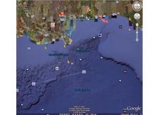
Last week, Google launched Google Earth 5.0. This version includes the long-expected addition of oceanic images and bathymetry. People will be able to see the underwater topography; search for particular...
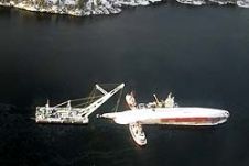
In December 2007, the Fugro survey vessel Geo Prospector was performing part of the Detailed Marine Survey for routing the proposed Galsi gas pipeline across the Southern Mediterranean Sea between...
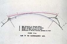
Before and during the Second World War, there were several developments in electronics that changed the course of hydrographic history. These aircraft bombing systems were what ultimately led from the medium-frequency...
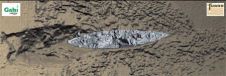
In January 2004, the M/V Rocknes hit a shoal in Vatlestraumen near Bergen (Norway), just minutes after leaving harbour. Only 11 of the 29 crew members survived the freezing waters....
As a first-time host, CodaOctopus Products is announcing the 44th meeting of the Marine Measurement Forum, taking place at the Scotsman Hotel in Edinburgh (Scotland) on 21st May 2009. ...
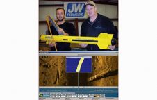
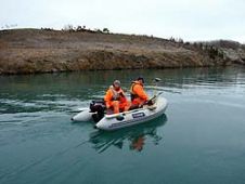
More commercial diving companies are adding side-scan surveys to the mix of services they offer. Some are purchasing sonars to provide them with the capability of finding lost objects, to...
Australasian Hydrographic Society Passing of rear admiral Sir David Haslam KBE, CB The AHS would like to express their sadness at the passing of Davis Haslam who served as the...
The Dutch East India Company, the Verenigde Oostindische Compagnie (VOC), was founded in 1602. In so doing it became the first multinational corporation in the world, and only the third...
Many universities are now adding ROVs to their marine science programs. These remote-controlled camera systems can assist in a multitude of operations including underwater archaeology, monitoring the health of benthic...
The "AMAP2 - Characterising the Potential for Wrecks" project (AMAP2), commissioned in October 2009, is a collaborative project between SeaZone and the University of Southampton (UoS) which seeks to improve...
This site uses cookies. By continuing to use this website, you agree to our Cookies Policy. Agree