NaviModel DTM Software
NaviModel software for ocean mapping, data analysis and interpretation provides intuitive 3D visualiasation of infinite survey data sets by import of multiple data formats and sources using user-defined templates. NaviModel...
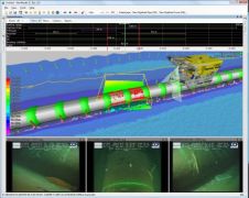
NaviModel software for ocean mapping, data analysis and interpretation provides intuitive 3D visualiasation of infinite survey data sets by import of multiple data formats and sources using user-defined templates. NaviModel...
The latest version of SeaZone GeoTemporal Editor is to be released during OI2010. This software solution aims to improve and simplify the management, analysis and presentation of geographic and environmental...
Nortek AS have partnered with WaveForce Technologies to create a new comprehensive directional wave post-processing software toolbox called Wavector. Wavector is a set of modern ocean wave analysis tools in...
From now on, GIM International is your guide for GIS software. On this website, you will find a guide to GIS software that is available to download for free. Follow...
RBR is introducing a new cross-platform multi-instrument software application, Ruskin, that is the successor to the "RBR Windows" software. Ruskin has been written to enable multiple instrument and dataset support,...

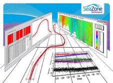
Ocean Business 2009 will see the launch of a software solution designed for the management of marine information. SeaZone's GeoTemporal software allows import, processing and presentation of marine data from...
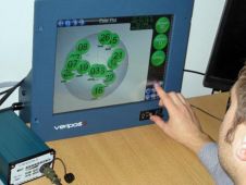
Veripos has introduced Verify DPx, a status monitoring and display software package specifically designed for dynamic positioning applications. The package operates in conjunction with Veripos LD3 integrated mobile units and...
On 15 February 2008, HYPACK officially released HYPACK 2008. This release represents almost a year of improvements to our previous version HYPACK 6.2B. HYPACK 2008 consists of a complete surveying...
This site uses cookies. By continuing to use this website, you agree to our Cookies Policy. Agree