Data quality factors for marine UXO surveys
Researchers involve stakeholders to define unexploded ordnance survey requirements
The detection of unexploded ordnance (UXO) in the sea is a demanding task. UXO survey data is acquired using a set of different sensors in different configurations and can span large areas. To make sure that the resulting highly complex dataset is fit for purpose, a well-defined workflow is crucial. Researchers of the BASTA project are therefore developing quantitative data quality factors to indicate how survey data should be acquired for the detection of a specified reference object.
Munition or unexploded ordnance (UXO) in the sea poses a threat during offshore work such as pipeline or platform construction, as well as to the marine environment. If UXO detection and clearance activities are executed erroneously, managed poorly or even omitted, UXO can threaten the lives of construction workers, the construction schedule, the marine fauna, and the public image of the parties involved. In response to these challenges, Frey (2020) developed the Quality Guideline for Offshore Explosive Ordnance Disposal (EOD). The guideline addresses the four phases of EOD: (I) a desk-based preliminary survey of historical data, (II) a technical survey in the field, (III) an investigation of suspected UXO sites, and (IV) UXO clearance and disposal. Other guidelines on marine UXO surveys or on hydroacoustic mapping that are relevant to munition surveys have been published by OWA (2020), IHO (2020), NOAA (2019) and IOGP (2009). All of these documents largely consist of a qualitative description of the workflows for marine geophysical surveys, and to some extent for UXO campaigns. GEOMAR and EGEOS are now working on a method to quantitatively describe a survey by defining data quality factors. Using such quality factors in the workflow can improve data handling, as more time can be spent on data analysis and interpretation. As multi-sensor datasets become larger and more complex, a well-defined workflow and consistent threshold criteria for data quality will increase project transparency and trust in the results. In addition, clear definitions will improve the communication between all partners involved in the UXO projects, from the project manager to surveyors and data analysts.
Methodology
The BASTA researchers apply the following steps to define the data quality factors:
- A literature review of all existing guidelines. Based on this information, an initial table of data quality factors for the reference object and for different relevant sensors (multibeam echosounder, side-scan sonar, sub-bottom profiler, magnetics) could be developed.
- This initial table of data quality factors was transformed into a questionnaire and sent to 125 experts in the field of marine UXO surveys. An updated table was then created based on the responses.
- Digital stakeholder workshops were held to discuss the data quality factors and threshold values that define whether the data is fit for purpose to detect a specified reference object. Two workshops each for magnetic and hydroacoustic sensors were organized, and 29 experts participated in the discussions. The workshops lead to the definitive agreement on 57% of the discussed data quality factors, while the remainder is still under discussion. Again, the table of data quality factors was updated.
- In a final event, to take place during the Kiel Munitions Clearance Week 2021, the remaining, not yet agreed upon quality factors will be discussed further.
Data quality factors – preliminary results
General definition
We distinguish between the reference object data quality factors and sensor data quality factors. In the process described above, these were identified by answering the following questions:
- Reference object: Which reference object data quality factors need to be provided after the preliminary survey and before the selection of the sensor?
- Sensors: Which sensor data quality factors are important to determine whether the survey data is fit for the purpose of detecting a specified reference object?
Once these questions had been answered, a standardized UXO survey workflow that is based on transparent data quality factors could be developed. A preliminary version of the workflow for multibeam surveys is illustrated in Figure 1.
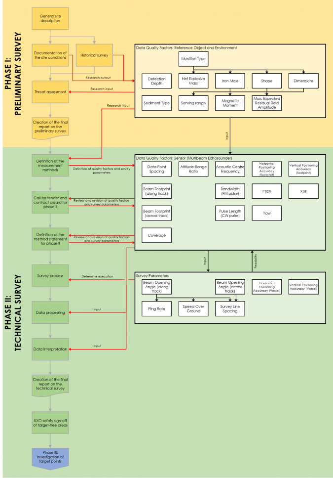
The flowchart illustrates that the historical survey and the documentation of the site conditions are the principal inputs to the definition of a reference object. This is the smallest object that needs to be detectable in the survey data and is commonly defined following a threat or risk assessment. All reference object quality factors are therefore an output of the preliminary survey (Phase I). Note that not all reference object quality factors are relevant for multibeam systems, as the reference object needs to be defined (and thus its quality factors determined) before the survey planning begins.
The reference object and its properties are the inputs to the technical survey (Phase II), in which measurement methods are defined and subsequently reviewed and revisited by the client and the contractor during the tendering and the definition of the method statement for the survey. In addition, a number of survey parameters define how the survey process itself is executed. The method statement must therefore balance data quality requirements and the survey feasibility requirements. Knowledge of all data quality factors is relevant for the subsequent data processing and data interpretation processes.
Similar workflows were prepared for all sensors that are commonly used in UXO detection surveys, and are available on the BASTA project website. These include the multibeam echosounder, side-scan sonar, sub-bottom profiler and magnetometer (Frey, 2020). More recent techniques such as electromagnetics, synthetic aperture sonar and possibly chemical sensors will be defined in the future.
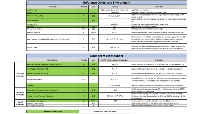
For the sensor data quality factors, threshold values need to be defined for the sensor. These act as an objective and theoretical requirement for the detection of the specified reference object. Since reference object data quality factors form the input to the technical survey, they act as controlling variables for many threshold values of sensor data quality factors. Table 1 shows the preliminary data quality factors for an example reference object as well as the resulting threshold values for multibeam data quality factors, which need to be defined before a survey can commence. Some quality factors in Table 1 were already agreed upon during expert discussions (green), while others are still under discussion (white). Detailed tables of data quality factors for all sensors considered so far can be found on the BASTA project website.
Practical application
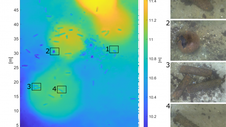
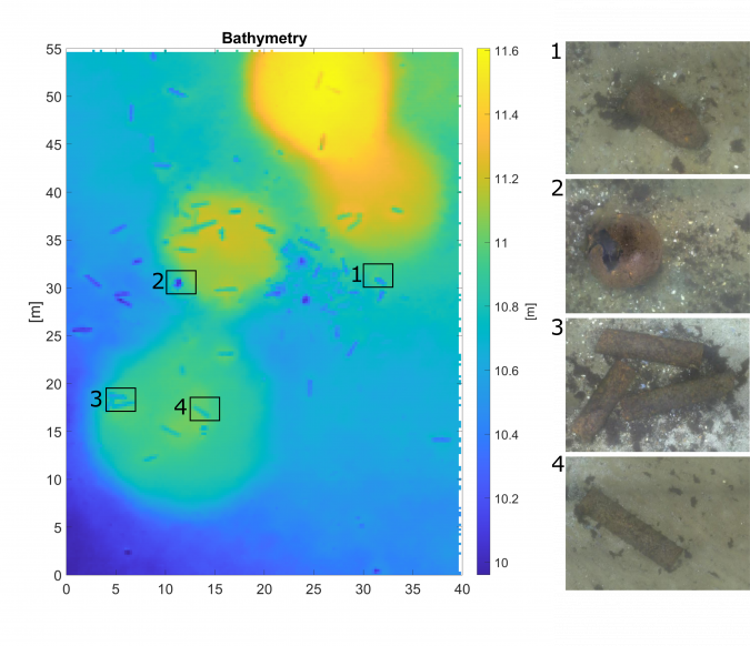
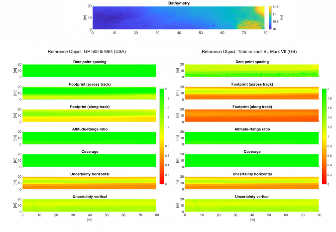
Figure 2 shows an example of a multibeam dataset of the German dump site Kolberger Heide and of a subsequent AUV-based camera survey. Several different UXO objects can be identified in the multibeam data, but how do we know whether all the UXO objects on the seafloor have been detected, or whether some smaller objects have been missed? This question is particularly difficult to answer for datasets that span large areas with varying water depth and seabed conditions. However, the definition of reference object quality factors and well-defined sensor data quality factors can help to answer this question. Figure 3 illustrates the data quality factors computed on the same real multibeam dataset for two differently sized UXO objects. The quality factors are computed relative to the threshold values defined in Table 1. The dataset seems to be generally sufficient for the detection of an aerial bomb (left column: GP 550lb M64). On the other hand, the computed footprints indicate that the smaller object (right column: 155mm shell BL Mark VII) would probably be missed in large parts of the survey area (please note that this working example is meant to illustrate the idea). Similar threshold values can be calculated for the other sensors that are listed in the workflows. Once the data quality factors have been finalized, the calculation presented in this paper will be available as features via AmuCad.org and TrueOcean.io.
Conclusion
A well-defined workflow and commonly agreed data quality factors for geophysical survey data can improve the project transparency for UXO surveys, as illustrated in the example. For complex datasets in particular, which include numerous sensors that need to be understood by multiple parties involved in a project, such guidance can facilitate communication between stakeholders. Since acceptance among industry experts is crucial for the future application of the data quality factors presented in this article, their definition is being facilitated through a stakeholder-driven process. The results presented here are preliminary and will be finalized during a workshop discussion to be organized during the Kiel Munition Clearance Week in September 2021.
References
Frey, Torsten (2020): Quality Guideline for Offshore Explosive Ordnance Disposal. 1st Edition. Berlin, Zurich, Vienna: Beuth Verlag GmbH.
IHO (2020): IHO S-44 Standards for Hydrographic Surveys, 6th Edition, Monaco: International Hydrographic Organization.
IOGP (2009): Guidelines for the conduct of offshore drilling hazard site surveys, Version 2.0, London: International Association of Oil & Gas Producers.
NOAA (2019): Hydrographic Surveys Specifications and Deliverables, National Oceanic and Atmospheric Administration.
OWA (2020): Guidance for geophysical surveying for UXO and boulders supporting cable installation, Offshore Wind Accelerator.

Value staying current with hydrography?
Stay on the map with our expertly curated newsletters.
We provide educational insights, industry updates, and inspiring stories from the world of hydrography to help you learn, grow, and navigate your field with confidence. Don't miss out - subscribe today and ensure you're always informed, educated, and inspired by the latest in hydrographic technology and research.
Choose your newsletter(s)


