
Examining developments in constellations, augmentation and receivers
Incremental improvements in GNSS
It is almost impossible these days to imagine geoinformation without GNSS, and most geodetic services have switched to GNSS to maintain their geodetic reference network rather than using traditional optical techniques. This article explores the state of the art in GNSS, from a constellation, augmentation and receiver perspective. Spoiler alert: it is more of an evolution than a revolution!
Global navigation satellite systems (GNSS) are everywhere. Try to imagine hydrography without GNSS, and you will probably fail. Some might say, “But what about underwater acoustic positioning?”, but these systems too rely on external positioning sources that are almost invariably GNSS-based. So, what is the current state of play when it comes to GNSS?
GNSS constellations
The number of GNSS constellations has remained constant in the past few years. Listed in the order in which they first became fully operational in their current configuration, they are: the USA’s GPS, Russia’s Glonass, China’s BeiDou and Europe’s Galileo. In fact, Galileo should not be included in this list of fully operational systems, since – at the time of writing – only 22 of the planned 27 plus three satellites were fully usable, with another two in the commissioning phase. However, Galileo will hopefully reach full operational status at some point in 2022.
As well as these four global navigation satellite systems, there are two regional systems. The Japanese QZSS is probably the best-known of these, with both geostationary and quasizenithal geosynchronous satellites, providing coverage of Japan. Another three satellites are planned for QZSS in 2023 that will provide positioning over Japan (and Australia), bringing the constellation to seven satellites. The second regional system is NavIC (or IRNSS, as it was known until 2016), which orbits over India. Again, this system has both geostationary and geosynchronous satellites and covers India and the Indian Ocean. As both QZSS and NavIC are purely regional, they cannot be used outside their particular regions. This is in stark contrast to ‘true’ GNSS, although BeiDou is actually both regional and global as the system employs geostationary and geosynchronous satellites over China and satellites that orbit the world in a medium Earth orbit like the other three GNSS. The advantage of this is greatly improved coverage over China (and Australia). As a result, the Australians probably have the best GNSS coverage in the world, with a total of five available systems. India can also use five systems for navigation, although it is close to the edge of BeiDou’s coverage.
In terms of development within the various systems, the signal structure has remained the same for most systems and improvements have mainly been made in the control and positioning of the satellites themselves. Although these are relatively small improvements, they do have a sizable impact because a more accurately positioned satellite translates into better on-the-ground accuracy. The only system to have undergone intrinsic improvements is Glonass. Starting in 2018, a series of satellites was launched with the new L3OC signal. This CDMA signal is easier to implement than ‘standard’ FDMA signals because the CDMA signal uses similar techniques to those in the other GNSS. However, it has now been well over a year since the last launch (in 2020) and – especially considering the current conflict situation – the current plans for Glonass are unclear.
GNSS augmentation
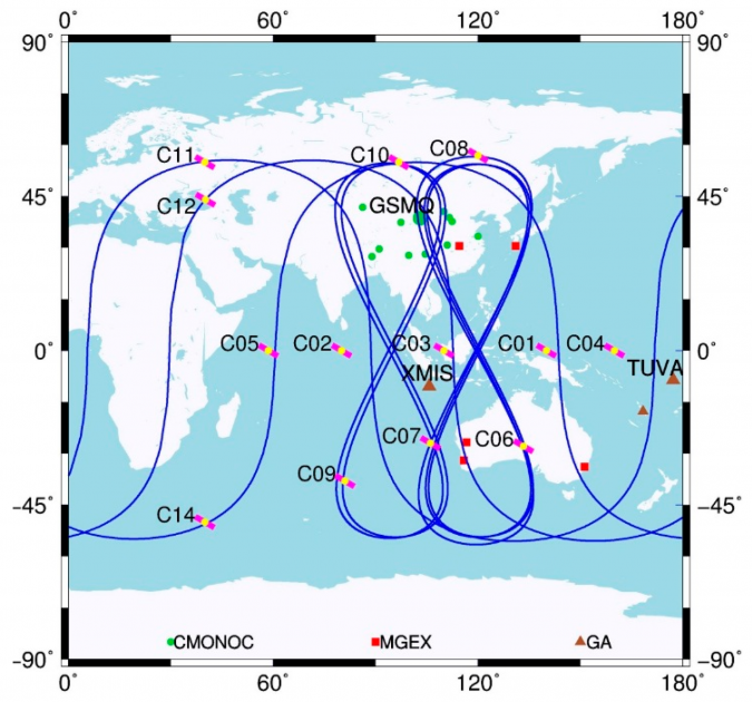
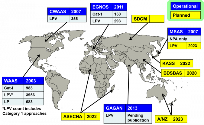
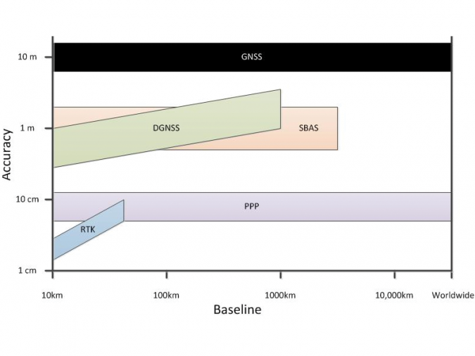
Whether for hydrographic surveying and other professional geoinformation work or for smartphones and vehicles, and whether in the USA, Europe or Asia, the ‘raw’ GNSS signal is rarely used. Rather, an improved, augmented signal is used thanks to a number of ‘free’ (i.e. government-sponsored) space-based augmentation systems (SBAS): WAAS in the USA, MSAS in Japan, Egnos in Europe and Gagan in India. Other systems are at varying stages of development or certification, including SDCM (Russia), KASS (Korea), BDSBAS (China), SouthPAN (Australia), SACCSA (South/Central America and the Caribbean) and A-SBAS (Equatorial Africa). Each of these systems essentially functions as follows. Control (‘base’) stations on the ground receive the satellite positioning signals and compare the signals actually received to those expected. Based on a number of these measurements, corrections for the augmentation area are developed and transmitted to a geostationary satellite, from where they are sent back to the receivers in the GNSS frequency bands. These satellites are often recognizable in the sky plot by the ‘high’ satellite numbers they display. Due to the rather large areas covered by SBAS, the resulting accuracy is reasonable but not extremely high.
When a high horizontal and vertical accuracy is required and when close to the coastline, real-time kinematic (RTK) augmentation systems are used. Depending on the set-up, surveyors can use their own base station with UHF corrections, for example, or make use of an existing network. If an existing network is used, they can use corrections from a single base, but surveyors often use a virtual reference station whereby the network ‘computes’ a set of corrections as if the base station were located at or near the survey area. Sub-centimetre accuracies can be achieved using a local base station and post-processing the results (rather than using them in real time). However, the disadvantage of RTK is that the range is limited to around 15km from a (virtual) base station. As a result, RTK is unusable for ‘true’ offshore work, unless a base station can be installed locally. This could be the case in for example a wind farm, where a base station is installed on a transformer platform. In other conditions, RTK is only usable for inshore and near-shore survey work.
Precise point positioning (PPP) lies somewhere between these two technologies. Although it is not as accurate as RTK, the advantage of PPP is that it works over large areas without having to install a base station and is therefore usable in the offshore environment. In PPP, data from ground-based stations is used to model the local errors in the GNSS observations (rather than transmitting corrections). Using an iterative process of predicting the model errors and comparing them to the real results, the receiver iterates stand-alone positions to a high accuracy. A data link is still required to receive the model data, but this method is not limited by a range of just a few kilometres or the need for local reference points. The latest commercial services using all available GNSS coverage are now achieving sub-decimetre results in terms of both horizontal and vertical precision. The Galileo High Accuracy Service, which is expected to become initially operational somewhere in 2022 and fully operational from 2024 onwards, is based on the same principle but with a horizontal accuracy of around 20cm and a vertical accuracy of around 40cm. For single points, results similar to the commercial PPP systems can often be obtained (but without guarantees) by various freely available post-processing services such as Auspos CSRS-PPP and Trimble CenterPoint RTX post-processing. These services can therefore aid in the establishment of platform (and base station) locations without having to resort to a commercial PPP solution. Depending on the service, it may even be possible to post-process kinematic data (PPK) rather than just static data, therefore allowing vessel tracks to be post-processed at a later stage using highly accurate positions.

GNSS receivers
As with all hardware, the GNSS receiver is continuously being developed. However, based on recent specifications, it is apparent that the development is more of an evolution than a revolution. For hydrographic survey work, perhaps the greatest change has been that units are becoming smaller and smaller and have become truly black box systems. Besides some LED lights indicating the main status, everything is operated using a web interface. Furthermore, more and more units support heading computations rather than just position computations. And of course, almost every unit now has PPS output, as networked sensors require an accurate time stamp to operate correctly.
For those in coastal construction, perhaps the greatest change to the GNSS receiver has been the addition of an IMU, allowing the user to hold the pole ‘at an angle’ while measuring. This allows surveys to be completed much faster since the user no longer needs to wait for the bubble to centre before taking a measurement. Depending on the brand and model of the receiver, the achievable angles are anywhere between 15° and 60° of tilt.
The second major development in coastal construction is of course that the units are becoming ever-smaller for use on unmanned vehicles (both small ASVs and UAVs or ‘drones’). Whereas PPK on a drone would have been regarded as a benefit a few years ago, multi-frequency RTK systems are now becoming the standard for high-end systems. This trend is enabling surveyors to obtain much better models of construction projects without requiring as many ground control points to tie the photographs or Lidar data into the geodetic network.
Conclusion
As outlined above, incremental changes have taken place in GNSS positioning over the last few years. With ever-growing GNSS constellations, further developments in augmentation systems and upgrades to receivers, the improvements seem set to continue in the near future.

Value staying current with hydrography?
Stay on the map with our expertly curated newsletters.
We provide educational insights, industry updates, and inspiring stories from the world of hydrography to help you learn, grow, and navigate your field with confidence. Don't miss out - subscribe today and ensure you're always informed, educated, and inspired by the latest in hydrographic technology and research.
Choose your newsletter(s)


