Expanding the capabilities of autonomous USV systems
Assets on the seabed, such as offshore wind turbines, natural resource extraction systems and underwater cables, serve as critical subsea infrastructure. To efficiently build, monitor, protect and maintain these assets, autonomous system solutions are vital. Over-the-horizon uncrewed deployments with infrequent servicing can be achieved by vehicles, sensors and software working together to enable high-resolution data collection, as this data can then be used as real-time input for intelligent autonomous navigation in hardware setups with low energy consumption.
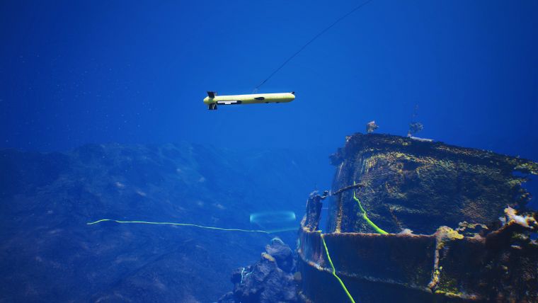
EIVA recently launched a new active towed sensor platform, ViperFish, which serves as a building block for autonomous systems as it is towable by uncrewed surface vehicles (USVs). USVs are often deployed for uncrewed operations that require small, fuel-efficient vessels and are being developed as platforms for autonomous operations. One limitation, however, is that USVs operate from the water’s surface, which varies in distance from the seabed rather than maintaining the ideal distance for the sensor collecting data. This ‘sensor sweet spot’ is important for operations with sensors such as sidescan sonars (SSS) for target detection and classification and magnetometers for locating buried targets such as UXOs, as well as for tracking buried cables in operations for the protection and monitoring of maritime critical national infrastructures. For USVs to become useful platforms for target detection in these types of operations, one possible setup is actively towing a sensor platform behind the USV.
The ViperFish ROTV can expand the capabilities of autonomous USV systems to include the accurate and reliable detection and classification of targets such as MILCOs or damage to critical subsea infrastructure. Its design is optimized for autonomous systems through low energy consumption, high-quality data collection and integration between hardware and software – for example with automated steering modes.
Automatically following the seabed
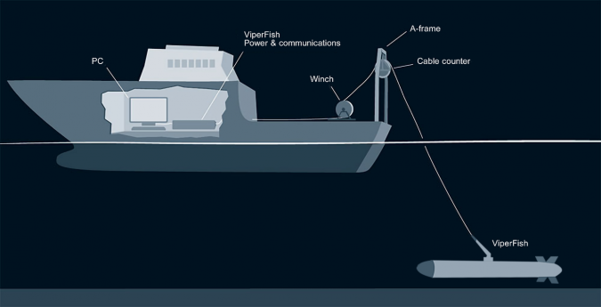
To ensure optimal data collection, ViperFish must position the sensors precisely. This is achieved with 3D control and automation electronics and software technology originally developed by EIVA for the ScanFish ROTV, the industry-leading UXO survey sensor platform. Using the Follow Seabed automated flight mode, EIVA’s ROTVs follow the seabed terrain at a fixed distance. To further optimize this, the ROTV flight control software can be upgraded with EIVA’s software toolbox, NaviSuite. This integration enables operators of the ROTV to use MBES data (real-time from vessel or pre-survey) for early warning to make the ROTV automatically avoid steep obstacles more smoothly with the flight mode Vessel-Aided Terrain Follow. This ensures stable data collection and safe ROTV operations, even in areas with steep obstacles.
ViperFish can be steered both vertically and horizontally, meaning that runlines can be input to the ViperFish ROTV’s Flight software, and it will follow them exactly. This capability to maintain a horizontal position ensures optimal area coverage by minimizing the risk of gaps in the data.
Maintaining sensor angle and smooth movement
In addition to positioning the location of the sensors precisely, ViperFish keeps the pitch consistent by remaining horizontal even when following the seabed’s uneven terrain. This is achieved through active flaps that minimize pitch changes caused by vertical steering. The design also minimizes turbulence through laminar flow, resulting in smooth, stable movement. ViperFish experiences low drag and minimal turbulence thanks to the system design, resulting in low energy requirements.
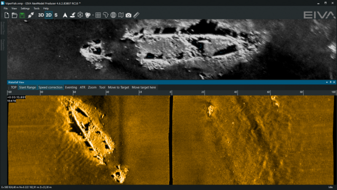
In addition to tools for vessel-aided obstacle avoidance and mission planning, the NaviSuite software provides sensor data fusion display with seamless integration of data from multiple sensors, real-time data cleaning, automatic target recognition and logging and the possibility of developing custom software tools. Moreover, the NaviSuite software features deep learning algorithms and automatic target recognition capabilities, empowering surveyors and navy operators alike with enhanced detection and classification capabilities.
High-resolution imaging and precise positioning
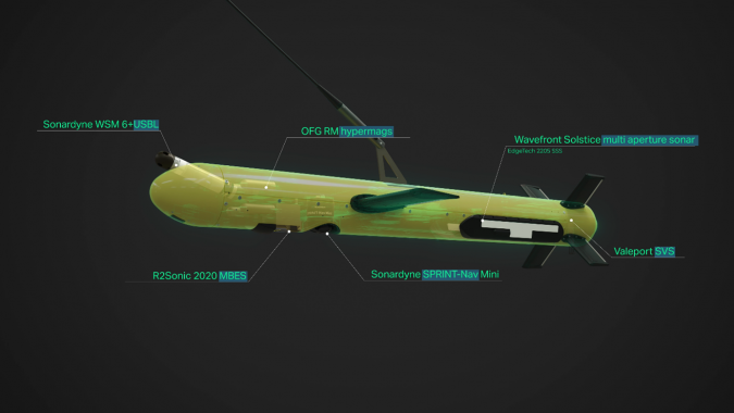
ViperFish’s state-of-the-art sensor payload provides a holistic understanding of underwater environments, enabling comprehensive data acquisition in various operational scenarios. Users can choose from a list of integrated imaging and positioning sensors based on their specific requirements: objects and structures on the seabed can be imaged using Solstice multi-aperture sidescan sonar and R2Sonic MBES, while OFG magnetometers aid in locating buried UXOs, MILCOs, cables and more.

Value staying current with hydrography?
Stay on the map with our expertly curated newsletters.
We provide educational insights, industry updates, and inspiring stories from the world of hydrography to help you learn, grow, and navigate your field with confidence. Don't miss out - subscribe today and ensure you're always informed, educated, and inspired by the latest in hydrographic technology and research.
Choose your newsletter(s)


