Exploring new horizons for ocean observation
Exploiting unmanned surface vehicles to collect ocean data
As the informed readership of Hydro International knows, the oceans sustain the planet. And, while there are many drivers of the changes to the Earth’s climate that now pose an existential threat to humanity, the health of the oceans is arguably the most important factor for ensuring a healthy climate. There is mounting evidence that the world’s oceans are under increasing stress and that we must find a sustainable way to protect them. An essential element of doing so is making data-driven decisions as to what steps to take to sustain the 70% of the planet covered by water.
Background
Data-driven decisions cannot inform those with stewardship of the world’s oceans unless we collect the right data, at the right places and at the right times. However, where those with stewardship of various aspects of ocean sustainment cannot find an affordable way to collect this data, it will very likely not be obtained and, unfortunately, large gaps in the data will lead to an incomplete picture. Clearly, this is a situation that degrades the chances of achieving long-term ocean health.
In the recent past, the failure to accurately assess temperature, current, wind, salinity, bathymetric, hydrographic and other oceanic conditions could be forgiven, as there simply were no affordable ways to do so on a repeatable basis. Today, however, unmanned maritime vehicles of various types can be used; in particular unmanned surface vessels, or USVs. While there have been some tentative attempts in the past to employ USVs to collect such data, there have been few – until now – comprehensive evaluations of this capability.
A United States best practices example of a unified effort to collect oceanic data
The US National Oceanic and Atmospheric Administration (NOAA) and the US Navy have formed a partnership to obtain and utilize unmanned maritime systems for a variety of missions, most notably to assess the health of littoral and oceanic waters. These two major oceans stakeholders recently signed an agreement to jointly expand the development, acquisition, fielding and operations of unmanned maritime systems in the nation’s coastal waters as well as in the world’s ocean waters. This will enable NOAA to leverage the Navy’s expertise, infrastructure and training to accelerate its science, service and stewardship mission.
The new arrangement corresponds with rapid expansion and innovation in the use of unmanned systems across the government, academia and private enterprise. The new pact formalizes the US Commercial Engagement through Ocean Technology Act of 2018 that directs NOAA to coordinate with the US Navy on a wide range of functions, including research in emerging unmanned technologies.
From aspirational ideals to progress on ocean observation
This NOAA-US Navy partnership is an important initiative that underscores the vital nature of robust data collection and why this is critical for ensuring the health and vitality of the world’s oceans. For both the US Navy and NOAA, a major appeal of unmanned systems is that they provide a persistent sensor picture to ascertain various aspects of the ocean’s health.
Given the importance of ocean observation as a critical ingredient for ensuring the long-term and sustainable health of the oceans, unmanned systems have a strong appeal. Due to the prohibitive costs of using manned aircraft or seacraft to conduct these observations, as well as the dangers of using these vessels in bad weather, in turbulent waters or at night, the only effective solution may be to invest in affordable USVs to conduct these observations.
In support of NOAA and US Navy objectives for ocean observation, one US company, Maritime Tactical Systems (MARTAC), was invited to demonstrate the use of commercial off-the-shelf USVs to conduct a comprehensive environmental monitoring evaluation. This month-long endeavour was conducted under the auspices of the Naval Meteorology and Oceanography Command (CNMOC). Under CNMOC’s stewardship, an advanced naval training exercise (ANTX) was conducted in the Gulf of Mexico, south of Gulfport, Mississippi.
Equipping unmanned surface vessels for effective ocean observation
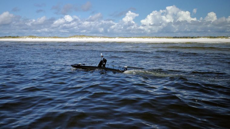
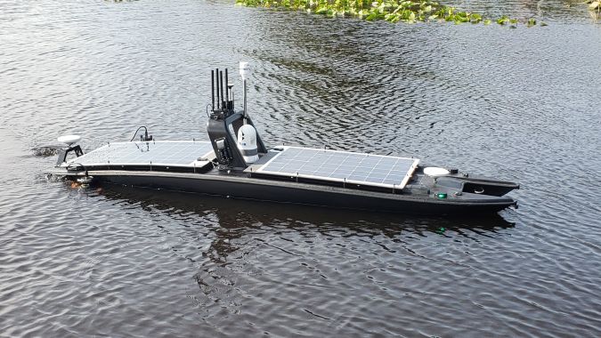
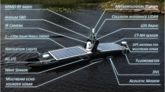
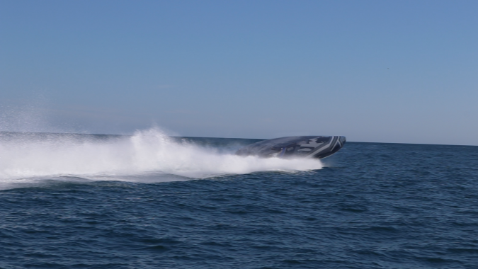
Having a capable USV is only one part of conducting a comprehensive ocean observation exercise. CNMOC scientists outfitted a Mantas USV with a CNMOC Environmental Monitoring System. These systems and sensors were designed to provide a one-vehicle solution to environmental sensing that was, in the past, conducted by multiple platforms. Key to the success of this ANTX was the fact that the catamaran-hulled, compartmented Mantas USV was outfitted with solar panels which enabled it to remain at sea for 30 continuous days.
In order to have this single USV conduct comprehensive environmental monitoring of the Gulf of Mexico, CNMOC equipped it with nine sensors: (1) a Teledyne Benthos ATM603 underwater modem, (2) a FLIR M232 camera, (3) a Teledyne Citadel CTD-NH conductivity temperature depth monitor, (4) a Teledyne DVL with ADCP Doppler Velocity Log, (5) a Norbit iWBMSh-STX echosounder, (6) a Turner C3 fluorometer, (7) a Quanergy M8-1 Plus Lidar, (8) an Airmar WX220 MET meteorological sensor and (9) a SeaView SVS-603 wave height sensor.
In order for CNMOC officials to have real-time information on ocean conditions, four different communication systems were utilized: line of sight (LoS), 4G LTE, Silvus radios and Iridium Short Burst Data. The use of multiple communication paths was important to the ability of CNMOC scientists and engineers to change the paths of the USVs as different sets of data were collected and new search patterns were needed.
Conduct of the advanced naval training exercise
CNOMC conducted the testing described above, and it was so successful that the command employed a second USV (another Mantas USV) equipped with a different suite of ocean monitoring systems and sensors. These included a Norbit iWBMSh-STX echosounder coupled with a Klein UUV 3500 sidescan sonar. As testing continued with both USVs, CNMOC scientists and engineers provided vital feedback and suggested several enhancements to these vessels.
An important aspect of demonstrating the cost-effectiveness of employing commercial off-the-shelf USVs during this CNMOC ANTX was the ability of one operator to control both USVs simultaneously as they conducted surveys along specific paths, even with high sea states and currents of up to five knots. The ability to conduct surveys in higher sea states and in the presence of strong currents had thwarted other USVs in the past, and was one of the highlights of this month-long event.
Other uses of unmanned surface vessels – dealing with episodic ocean events
Beyond the collection of vital ocean data, another area in which USVs can make an important contribution to monitoring ocean health is in response to real-world challenges. The testing described above occurred in the littorals of the Gulf of Mexico, an area that has more than its share of environmental challenges. USVs are an ideal asset for evaluating the extent of damage as a first step in triaging the problem.
Again, this is a specific US example, but USVs can be used to measure freshwater run-off from rivers which can kill a great deal of marine life, as well as to identify green tides and red tides that affect tourism in local regions. Using a solar-powered USV that can remain at sea and monitoring the environment for up to 30 days at a time can alert communities to the extent of these green and red tides. This enables officials to be more exact in determining which beaches should close and which ones can remain open.
Moving forward with effective, affordable ocean observation assets
The use of the commercial off-the-shelf USVs successfully employed during this demonstration can be readily scaled-up in oceans, seas, bays, rivers and other waterways and can lead the way to enhanced data collection and transmission and the evaluation of water conditions. The results will help to sustain a healthier ocean.
As a major step forward in this effort, US Navy officials encouraged the Mantas USV manufacturer, MARTAC, to scale up the 12-foot Mantas used for this effort and produce larger vehicles. This was accomplished this year and a larger, 38-foot Mantas USV was deployed during the US Navy exercise Trident Warrior with positive results. These larger vessels will be ideal USVs for conducting ocean observation due to their ability to carry considerably more sensors and remain at sea for longer periods.
Conclusion
During a recent webinar, NOAA’s deputy administrator indicated that two of the primary priorities this year for NOAA are ocean mapping and ocean health. Leveraging USVs to accomplish these priorities will go a long way to protecting the oceans. We envision a tremendously increased demand for unmanned systems prototyping and experimentation to support robust and continuous ocean observation. The vast array of technologies emerging with today’s unmanned maritime systems provides a tremendous opportunity to move forward with an effective and affordable ocean observation taxonomy.

Value staying current with hydrography?
Stay on the map with our expertly curated newsletters.
We provide educational insights, industry updates, and inspiring stories from the world of hydrography to help you learn, grow, and navigate your field with confidence. Don't miss out - subscribe today and ensure you're always informed, educated, and inspired by the latest in hydrographic technology and research.
Choose your newsletter(s)


