Geomatics Usage on the Costa Concordia
Marine and Terrestrial Surveying During Emergency Response Operations
On Friday 13 January, the luxury Italian cruise ship Costa Concordia with more than 4000 people on board ran aground off Isola del Giglio’s coast after hitting a reef as the result of a thoughtless manoeuvre. Launched in September 2005, and having costed approximately EUR450 M, the 290 metres ship partially sunk and is now lying along the shoreline. The accident caused 17 deaths and 15 persons are still missing among the passengers and crew. Early intervention in the search for missing people was conducted by the divers of fire brigade squads recruited from all over Italy.
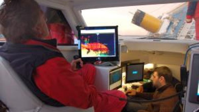
The divers of the Milan squad, for example, reached the site of the disaster with its research vessel Nereide. Equipped with multi-beam, laser scanner and auxiliary instruments a complete and precise overview of the situation was made in order to co-ordinate the search and rescue operations and to provide maximum safety to the rescuers.
Survey Platform and Instruments
On Tuesday the 17th, given the critical situation, the governmental body of the fire department requested the support of Codevintec, a technology supplier in the Marine and Earth Sciences for almost 40 year. Codevintec’s expertise was needed to ensure a successful survey mission from the very beginning (the fire brigade had purchased the hydrographic equipment only recently and an advanced user training was planned for the weeks right after the disaster).
The fire department wanted to have a complete overview of the site of the accident and also means to monitor the movements of the vessel.
Codevintec received the request for mobilising and operating a survey system on board the vessel Nereide. Codevintec’s engineers mobilised the vessel with a multi-beam Reson SeaBat 7125-SV2, Optech ILRIS-HD laser scanner, positioning system, attitude measurement system and Reson PDS2000 acquisition and processing software. The use of the two instruments enabled the creation of a virtual geometric precise model of the entire site, excluding the water surface, to fulfil the requirements of fire brigade.
The Reson 7125 multi-beam with 512 beams and 165° swath coverage collected high- resolution 3D data on-site underwater situation. The bathymetric data was merged with terrestrial laser scanning data, making use of the Optech ILRIIS laser scanner, capable of measuring up to 3000 metres of range.
Even though based on two different measurement principles, the sonar being based on sound principle while the laser scanner is based on light principle, both instruments provide the same type of end-result. Both systems produce a dense point cloud which can be assimilated to a 3D picture by making use of the 3D coordinates.
Marine Survey of the Costa Concordia
The vessel Nereide was mobilised on Wednesday morning and the first results were already made available to the Commander of the ‘crisis unit’ (fire brigades commander head of the rescue operations), Costa Crociere’s crisis unit co-ordinator and the other technical parties involved in the decisions process on the same afternoon.
After resolving all interface problems, measuring all offsets, performing calibration and synchronisation, a problem was identified with the data synchronisation between the laser scanner and the motion sensor. This problem was probably due to the incorrect impedance of the cables and connectors used to split the electrical 5V Pulse Per Second signal (PPS) coming from the GPS and shared to all the different sensors. The difference in impedance had probably created some false bounced PPS signals in the laser scanner which put it out of sync during some parts of the survey. Due to time constraints this issue could not be resolved.
From the side of the sonar, the problems occurring were from the specific nature of the area to be surveyed: the flat metal hull of the Costa Concordia acted as a mirror to the acoustic wave forms from the multi-beam and thus created shadows and artifacts that actually were not there. Fortunately, the Reson 7125 was equipped with the latest FlexMode option, which allowed us to direct the major sonar beams to the areas of interest, while avoiding those that could create problems.
The FlexMode option, available in most of the new series of Reson multi-beam, allow for the distribution of the beams of the seafloor in a more efficient way: it was developed mainly for pipeline inspection, where most of the 511 available beams are concentrated in a small portion of the swath where the pipe lays, while the rest of the beams provide the bathymetry of the outer area up to 165° of swath aperture.
With this option, the survey team was able to concentrate the beams to the area where they supposedly had more chances of success.
Survey Operations from Land
The same laser scanner used dynamically on board of the Nereide, was also used to scan the Costa Concordia shipwreck from a static position on-shore. These results were used as a reference for consequent scanning data made by the University of Florence with the aim of analysing not only possible movements of the wreck, but also its deformations. This technique is quite common to monitor land deformations (i.e. landslides or structures). The millions of 3D points compose an image, which in turn can be compared with millions of 3D Points coming from subsequent laser scan surveys. This made it possible to create a deformation map of the Costa Concordia.
On 19 January, the Istituto Nazionale di Geofisica e Vulcanologia (INGV) installed a seismic station, Nanometrics Taurus, which was supplied by Codevintec. This station showed the seismic activity of the area and monitored the telluric movements that could produce the instability of the wreck, as occured with the earthquakes suffered in north of Italy on 25 and 27 January 2012.
Movements
Codevintec also organised the use of a GPS RTK technique in an ‘unconventional’ way to monitor the ship’s movement real-time. This particular activity was conducted by HERA (a survey company from Grosseto) by placing a ‘reference’ GPS receiver on board of the vessel and a ‘mobile’ GPS receiver next to the crisis unit’s base. In this way, any apparent movement shown on the ‘mobile’ station was actually due to vessel movement.
Before the installation of the GPS, the movements of the Costa Concordia were monitored by a single total station tracking three prisms placed along the boat. Even if precise, this single solution suffered the lack of integrity due to the absence of cross checking with other measurement systems.
After the initial emergency operations, the monitoring activities were taken over by and carried on by the Civil Protection Department with more specific instruments, including a prototype of a new and compact SAR (Sintetic Aperture Radar) interferometer developed by the Joint Research Center (JRC) in Ispra, co-ordinated by the University of Florence.
The Results
Despite the minor problems suffered, all the crisis team participants were very impressed by the ability to make a virtual model of the actual wreck, enabling them to view the wreck from different angles and take measurements to make decisions for the further search and rescue operations.
The collected bathymetric and terrestrial laser scan data was compared with other data such as the GPS and total stations information. The goal of all these surveys has been to monitor the ship movements, verify the scull, discover and analyse anomalies and objects lying on the seafloor, and obtain accurate bathymetry in order to be able to foresee in which direction and mode the wreck might move. These operations were performed mainly to ensure the safest conditions for the divers and the speleologists operating inside the Costa Concordia, and to be able to start the delicate operation of removing the fuel from the tanks and avoiding a possible environmental disaster.
Thanks to all the acquired data, it has been possible to ascertain that the ship movements noticed during the first aid phase which worried the intervention squads, were only structural deformations of the ship itself during the assessment phase on the rocks, and not the ship slipping towards the abyss.
All the operations made by Codevintec, together with the fire brigade and the crisis unit, were part of the initial rescue actions. Afterwards, all the survey and monitoring operations were conducted by the Civil Protection Department and its Centers of Competence, i.e. government research bodies such as the University of Florence (with Laser Scanner), CNR-IRPI (with automated monitoring system based on Total stations), INGV (with Nanometrics seismic stations), OGS (with Reson 8125 multi-beam system), etc. who arrived on the island during the following days and were officially established on Saturday 21 January.
All the data collected by Codevintec up to that date were then distributed to the different researchers so that they could continue with the monitoring operations.
Acknowledgements
The authors wish to thank the fire brigade, which managed all first aid operations and provided extraordinary assistance to relief operations, and in particular to the divers squad who demonstrated outstanding professionalism and dedication.
Heartfelt thanks goes also to Dario Conforti of Optech who supported us with data processing while flying from one corner of the globe to another.

Value staying current with hydrography?
Stay on the map with our expertly curated newsletters.
We provide educational insights, industry updates, and inspiring stories from the world of hydrography to help you learn, grow, and navigate your field with confidence. Don't miss out - subscribe today and ensure you're always informed, educated, and inspired by the latest in hydrographic technology and research.
Choose your newsletter(s)


