The search for Vasco da Gama’s lost ships
Esmeralda and São Pedro
Two Portuguese ships from Vasco da Gama’s second voyage to India that were left behind in the Gulf of Aden to disrupt maritime trade through the Red Sea were wrecked during a storm in 1503 off the coast of Al Hallaniyah Island, Oman. The remains of at least one of these ships were found in 1998, prompting a search for the second ship to be undertaken in 2013. The geophysical survey was complicated by environmental conditions, but succeeded in locating all the cultural heritage material in the bay.
The Portuguese ships that were the target of this research, and the ensuing searches, are two of the most interesting and early European ship losses to have occurred in Oman and the greater Western Indian Ocean. The two ships, Esmeralda and São Pedro, were commanded by da Gama’s maternal uncles, Vicente and Brás Sodré. Extensive archival research identified two potential locations for the wreck site, which were searched by a small team in May 1998. Nothing was found at the first location on the western side of the island so the team then moved to the eastern bay and almost immediately found more than 20 stone cannonballs in shallow water close to the shore. During a second more extensive expedition that same year the team located more stone shot, a lead sounding weight and other artefacts suggesting that at least one of the shipwrecks had been found. Work was suspended because of logistical difficulties, but was restarted in 2013 as a collaborative project with Oman’s Ministry of Heritage and Culture (MHC). One of the aims of the current work was to undertake a detailed geophysical survey to locate the remains of any ships lost in the bay and to learn more about the wreck site located earlier.
Ghubbat ar Rahib Bay
The bay where the wreck material was found provides natural shelter from the southeastern monsoon making it an anchorage that has been used for centuries. It was known that the steamship City of Winchester was scuttled in the bay in 1914 and the cargo ship Al Quasmi was wrecked on the western shore in 1999. These two ships are large and made of steel and thus easy to locate, but the Portuguese ships were small vessels made of wood, a material which does not survive well underwater.
Historical accounts suggested that one of the Portuguese vessels was wrecked very close to shore whilst the second vessel may have sunk in deeper water. Any vessel on the shore would be destroyed but some structure may remain if the ship sank in deep water and was quickly covered by sediment. The iron anchors used by the ships and the tons of ballast stones they carried might also mark where the hull sank. It was known from the historical accounts that the surviving crew salvaged as much of the wrecks as they could, and with the eroding effects of the sea there may be little remaining of either ship. The geophysical survey would therefore need to be of high quality in order to detect the smallest objects on the seabed.
Logistics
The survey was challenging because of the remote location of the island off the southern coast of Oman, the shallow depth of the water inshore and the difficulty of detecting such ancient shipwrecks. Because of the shallow water the survey vessel needed to be small yet large enough to support the survey equipment and operators. A Geometrics G882 caesium magnetometer with a Tritech altimeter was used to detect iron objects. Only a small amount of iron was expected to survive so the highest quality magnetometer was needed for detecting the smallest magnetic anomalies. Wooden shipwrecks often erode away leaving only a ‘ghost’ of the wreck on the seabed so a high-resolution Edgetech 4125 Dual Frequency (400/900kHz) side-scan sonar was used. Positioning was provided by a C-Nav 3050 GNSS and bathymetry was measured using a simple Garmin fish-finder.
Smallest targets
The sonar survey was run at a slow speed and short range in order to detect the smallest possible targets. The side-scan tow fish was maintained at an altitude of 6m above the seabed except in areas where the topography changed rapidly and the altitude was increased to avoid collisions. The survey objective was to detect any iron objects larger than 500kg requiring the magnetometer tow fish to be towed just 6m off the seabed and with a 15m separation between adjacent survey lines. Tow speed was maintained at 4 knots but was varied to keep the tow fish at the correct altitude above the seabed. The weather conditions for the survey were ideal with a flat calm sea and minimal current. In the shallow areas, the clear water allowed a spotter in the bow of the boat to see any rocks near the surface so they could be avoided.
Results
The side-scan sonar revealed that the seabed in the bay was a wide expanse of featureless sand with only a few targets visible. Of the 310 separate targets detected during the survey, 17 were repeatable, 198 were classified as poor and 95 were caused by marine life – depressions made by large stingrays.
Problems were experienced when processing the magnetometer data as there was a large magnetic field gradient across the whole survey area. The gradient was most extreme closer to shore with the background field changing up to 3.5nT over just one-metre distance in places. The large size and wide area of the magnetic anomalies indicated they were caused by underlying geology. This background magnetic ‘noise’ was so large that it masked any effects from iron shipwreck material on the seabed. Unfortunately, the area corresponded with the location of the inshore wreck site so it effectively hid any iron objects that may exist there.
Investigating targets
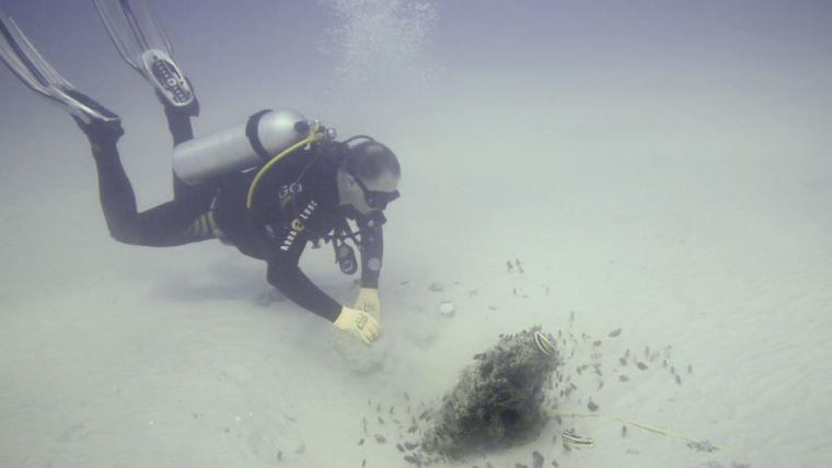
Each significant target detected by the side-scan sonar and magnetometer was investigated by divers. An Aquascan DX200 diver held magnetometer was essential for locating iron targets found using the towed magnetometer as all but two of them were deeply buried in the seabed. Close to shore the divers found that even the isolated targets were highly magnetic rocks that produced similar readings to those caused by man-made iron objects.
In the deeper waters of the bay, one small sonar and magnetometer target was identified as the fluke of a large iron anchor almost completely buried in the seabed. The anchor was found to be identical to one on the nearby City of Winchester wreck. One other target was the remains of a small steamboat partly buried in the seabed. No identifying marks were found on either the engine or boiler, however this tiny wreck is believed to be a pinnace from the City of Winchester.
Conclusions
The results showed that the bay did not contain the remains of many shipwrecks. The iron anchor that was lost in 1914 was buried under more than a metre of sediment indicating that any wrecks older than that date would by now also be completely buried. The inshore magnetometer survey did not detect any targets because of the background noise from magnetic rocks, but the area was carefully searched by divers carrying metal detectors and no shipwrecks other than the first wreck were found.
It is proposed that the wreck found in the shallows is the Esmeralda and that the São Pedro was washed on the shore before being broken up. The Esmeralda was found in an area where the rock ledge along the foreshore is wide with deep gullies, which acted as a trap for the ship and its contents. Had the Esmeralda been wrecked at any other point along the shore she too would have simply been washed up on the shore. Work continued on the wreck site in 2014 and 2015, which resulted in the archaeological excavation of more than 2,800 artefacts, including the ship’s bell, navigation instruments, rare gold and silver coins, pottery, beads and armaments consistent with the military mission of the Sodré ships.
Acknowledgements
This project was funded by Oman’s MHC and by grants to David Mearns from the National Geographic Society and Waitt Foundation.
More information
- The Esmeralda Shipwreck, http://esmeraldashipwreck.com
- David L. Mearns, David Parham, Bruno Frohlich, A Portuguese East Indiaman from the 1502–1503 Fleet of Vasco da Gama off Al Hallaniyah Island, Oman: an interim report, http://onlinelibrary.wiley.com/doi/10.1111/1095-9270.12175/abstract
- www.youtube.com/channel/UCHVM7l8t9CVd7enLH4byUTg/feed

Value staying current with hydrography?
Stay on the map with our expertly curated newsletters.
We provide educational insights, industry updates, and inspiring stories from the world of hydrography to help you learn, grow, and navigate your field with confidence. Don't miss out - subscribe today and ensure you're always informed, educated, and inspired by the latest in hydrographic technology and research.
Choose your newsletter(s)


