The search for the Montevideo Maru
Fugro’s hydrographic expertise locates sunken warship
Fugro has utilized its cutting-edge hydrographic technology in Australia to locate the final resting place of the Montevideo Maru, which sank in 1942 with more than 1,200 people on board.
The sinking of the Montevideo Maru in 1942 is the worst maritime disaster in Australia’s history. The vessel was carrying nearly 1,060 prisoners from 16 countries, including 850 Australian prisoners of war, and over 200 civilians aged 16 to over 60, when it was sunk off the Philippines by the USS Sturgeon. The ship was not marked as carrying prisoners and, while the fate of those onboard was not known until the end of the Second World War, the ship’s location remained a mystery. Fugro and the Silentworld Foundation took on a humanitarian expedition to find the Montevideo Maru’s final resting place and its passengers, to help bring closure to those affected by the tragedy.
Fugro’s company purpose is to contribute to a safe and liveable world. Hydrography plays a key role in this mission, supporting a range of scientific research for a better understanding of our oceans and helping to create a sustainable and resilient future. The Montevideo Maru project was important to Fugro, as their skilled employees were able to use their cutting-edge hydrographic technology to make a difference and unravel a mystery that had devastated the lives of many of the families involved; the hope being that the project would bring closure and peace at long last.
Before the search
Fugro and the Silentworld Foundation had previously worked together in 2017 on an expedition to locate Australia’s first lost submarine, the HMAS AE1. The submarine’s fate had been a mystery for over a century, after it failed to return from patrol in 1914. After this successful collaboration, discussion began almost immediately on the prospect of a future search, and the Montevideo Maru became that next expedition. And so Fugro began five years of careful planning with the Silentworld Foundation and the Rabaul and the Montevideo Maru Memorial, with support from Australia’s Department of Defence. On 6 April 2023, 110km north-west of Luzon in the Philippines, the team started the highly anticipated search.
Vessels and technology
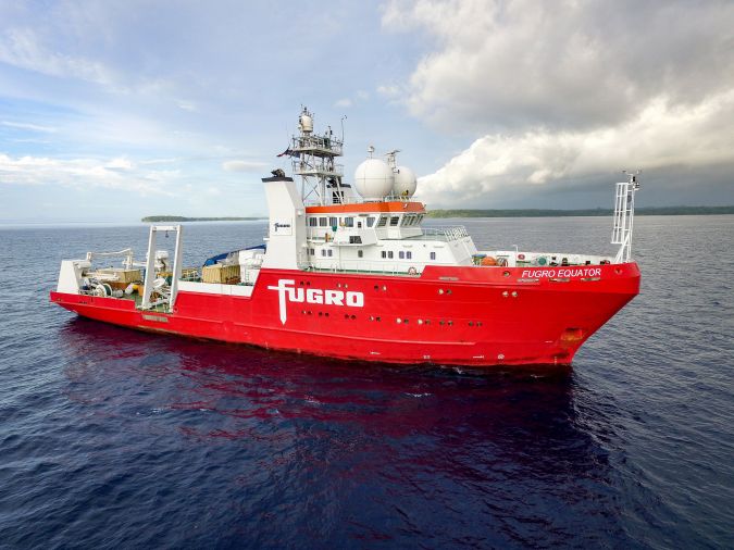
Fugro provided hydrographic support for the search in the form of its state-of-the-art equipment, together with a highly qualified and experienced team that planned and delivered the project. The Fugro Equator, a cutting-edge survey vessel equipped with a deepwater multibeam echosounder (MBES), led the search. The Fugro Equator can carry out a full range of offshore survey services, from simultaneous analogue and digital site surveys to full route surveys. The vessel is also permanently equipped with the latest hydrographic and positioning equipment.
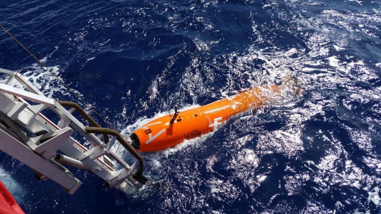
The underwater work was performed by the Echo Surveyor VIII (ES8), a Hugin autonomous underwater vehicle (AUV). AUVs are the ultimate tool for high-resolution imaging and accurate positioning of seabed and sub-seabed features and infrastructure. The ES8 is highly manoeuvrable and fitted with high-resolution MBES, synthetic aperture sonar and a high-resolution laser and camera that can reach a depth of 4,500m. This meant the AUV could cope with the search area’s deep water, collecting information without disturbing the seabed or the possible wreck site, all while the fast turnaround of deliverables transferred critical information into the right hands in real time.
The search and data processing
The project started with a reconnaissance of the search area west of the Philippines in water deeper than 4,000m. This initial survey used the deepwater MBES mounted to the hull of the Fugro Equator to establish a general understanding of the seabed geomorphology. These results and the acquired geodata were then used to plan the deployment of the AUV. The ES8 was used for the following high-resolution hydrographic search. ES8 collects geodata, including MBES and high-resolution interferometric synthetic aperture sonar (HISAS), and uses a Cathx camera to acquire high-resolution imagery of the seabed. The AUV was flown at altitudes of 100m above the seabed to identify the wreck site, with each mission lasting for 40 hours, followed by 10 hours of data processing onboard the vessel for each deployment. Once the site had been located via this hydrographic search, the ES8 was sent back into the ocean for lower altitude missions of between 45m and 6m to gather higher-resolution geodata. With each mission, the desired result came closer.
Echo Surveyor VIII (ES8), Kongsberg Hugin AUV, equipped with payload of:
|
Multibeam echosounder |
Kongsberg EM2040 |
|
Synthetic aperture sonar |
Kongsberg HISAS 1032 |
|
Sub-bottom profiler |
EdgeTech 2205 (2–16kHz) |
|
Camera |
Cathx colour stills camera with LED light panel Cathx laser camera and laser system |
|
Magnetometer |
OFG self-compensating magnetometer |
|
CTD |
SAIV, SD208 |
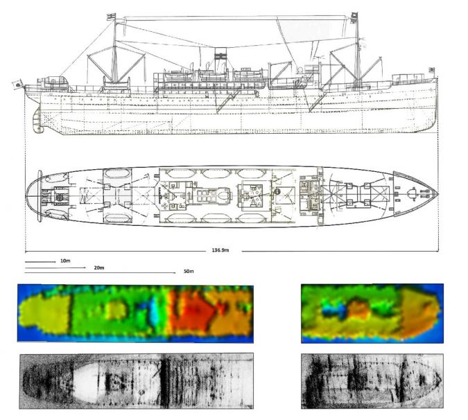
A key requirement for the search team was to ensure that the right wreck had been located; the search area covered multiple wreck sites and identification needed to be conclusive. Members of the research team onboard the vessel worked together with a team from the Australian Department of Defence led by Unrecovered War Casualties – Army, with onshore support from the Australian Hydrographic Office. Together, they played a key role in the search planning and identifying features from the wreck used for positive identification. The search team needed to be able to clearly demonstrate those features before the final survey of the wreck and acquisition of the high-resolution geodata.
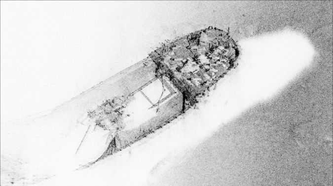
Hundreds of hours of data processing commenced. Once the project team of maritime archaeologists, conservators and research specialists worked through the geodata, it was clear that the Montevideo Maru had been found. The wreck site was located at a depth of over 4,000m, with the vessel having broken in two and lying in a debris field of cargo, including trucks, on the seafloor. The team worked hard to capture as much detailed information as possible without disturbing the site, to preserve it for further study by researchers and marine archaeologists.

Crew impact
The search started on 6 April 2023. After 12 days, the team had a first positive sighting with the AUV, but the geodata still had to be processed and the team had to wait for the results to be able to identify the wreck. The moment when the confirmation came through was incredibly emotional and exciting for the crew. The team was very proud of what they had achieved, but at the same time they were humbled. Many families have been touched by the Montevideo Maru tragedy, something that the team was mindful of throughout, and they will never forget the positive, grateful and relieved reactions from the families after the news was confirmed. Remembering those whose lives were lost that day will also continue around the world as numerous memorials are planned.
As John Mullen, chair of the Silentworld Foundation, commented: “Working with Fugro to successfully locate the Montevideo Maru was a fascinating and rewarding technical achievement, but it is the human dimension that has left the greatest impression. We have been overwhelmed by the extraordinary number of messages from descendant families who had never given up hope that one day the resting place of their family members would be found. It has been humbling to have been able, in a way, to bring a measure of closure to those families after so many years.”
Challenges of deepwater surveying
Fugro’s team of highly trained and dedicated survey professionals is experienced in deepwater operations and has the right vessels and equipment for a search like this, where the biggest challenge was identifying the most likely search area. Historians and archaeologists from the Silentworld Foundation were responsible for delineating the search area, while Fugro complemented this research with its understanding of the expected metocean conditions. After the search area was identified, the right team needed to be put in place for efficient logistical support on the project. A detailed reconnaissance plan of the area was also needed to make sure the ES8 could complete the search in the time available. This careful planning ensured that the ships and AUVs followed optimal search lines and avoided any hazards.
Future
The huge amount of geodata acquired during the search will be further analysed by marine archaeologists and researchers. This not only brings closure to those directly linked to the tragedy, but also contributes to our collective history and culture. The work underway from Fugro, the Silentworld Foundation and other partners will result in further releases of the detailed imagery, and so we can expect to see powerful visualizations based on these large quantities of acquired geodata.
Through maritime archaeology projects such as the Montevideo Maru, the community gains a greater awareness of the role of hydrography and our collective understanding of ocean science. They provide an important opportunity for outreach, demonstrate the advances in technology needed for a successful search, and showcase the benefits of underwater mapping. These all contribute to the conservation of marine ecosystems and align with Fugro’s sustainable development goals.
The Fugro Equator and its team have many more hydrographic and geophysical projects planned. The need for ocean data is greater than ever before and Fugro is involved in a range of global marine projects, from energy transition and the development of offshore wind farms to important sustainable infrastructure. Understanding the ocean, including its fascinating and sometimes tragic history, will play a key role in all our futures. Mark Heine, CEO of Fugro, concluded: “This maritime tragedy involved many countries and families, and all paid a terrible price. I am proud that our skills and technology can help find resolutions to historical projects such as this and, in this way, make a real difference to people’s lives. At Fugro, we’re using our hydrographic and oceanographic solutions to contribute to relief efforts and live up to our purpose of creating a safe and liveable world.”

Value staying current with hydrography?
Stay on the map with our expertly curated newsletters.
We provide educational insights, industry updates, and inspiring stories from the world of hydrography to help you learn, grow, and navigate your field with confidence. Don't miss out - subscribe today and ensure you're always informed, educated, and inspired by the latest in hydrographic technology and research.
Choose your newsletter(s)


