CHA Award 2008
The Canadian Hydrographic Association was created by a number of senior people in the Canadian Hydrographic Service in 1966/1967 in answer to a requirement for hydrographic training and professional status...
The Canadian Hydrographic Association was created by a number of senior people in the Canadian Hydrographic Service in 1966/1967 in answer to a requirement for hydrographic training and professional status...

MZT Pumpi AD was founded in Skopje, Republic of Macedonia, as a small fire-fighting pump manufacturer shortly after the Second World War. Over the years, the company has grown to...
This is the continuation of the Oceanology International Preview. For companies A - L, see part 1 MacArtney Underwater Technology Group MacArtney will be introducing their newest innovation in multiplexers...
Safe Software has announced the release of FME 2009 a spatial data conversion and distribution solution. This new version, which includes releases of FME Desktop and FME Server, has been...
Spool and jumper metrologies constitute a critical path in the subsea pipe installation process. They can often occupy large construction vessels ‘just’ for survey operations that may last more than...
SeeByte has been awarded a twelve month contract extension through the Office of Naval Research (ONR). PATT is a Performance Analysis & Training Tool developed by SeeByte which can be...
Safe Software has released FME 2008. The release includes the unveiling of FME Server, a scalable solution for data transformation and distribution, as well as a new version of FME...
Norway's Ulstein Group has entered into an agreement to acquire Maritime and Mechanical Technology (MMT), an engineering company that is based in Norway but which owns engineering companies in Croatia...
Nova Scotia is one step closer to building North America's first in-stream tidal technology centre to host some of the world's leading devices to harness energy from the world's highest...
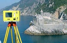
When surveying the coastline, the integration of bathymetric (below sea level) and laser scanning (above sea level) data causes problems due to the different imaging properties. However, by ensuring that...
This site uses cookies. By continuing to use this website, you agree to our Cookies Policy. Agree