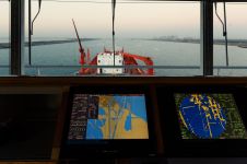
Bathymetric ENCs in confined waters
Electronic charts with greater scale and bathymetric content than any hydrographic office’s ENC (equivalent to a paper nautical chart) are not a novelty for many ports around the world. Such...

Electronic charts with greater scale and bathymetric content than any hydrographic office’s ENC (equivalent to a paper nautical chart) are not a novelty for many ports around the world. Such...
The Service of Hydrography, Oceanography, Meteorology and Nautical Charting (SHN) of the Venezuelan Navy recently initiated a series of tasks aimed at guaranteeing the safety of navigation along Venezuela’s main...

1 July 2018 will be a historic date for chart navigation at sea, states Mathias Jonas in a recent article. On exactly this day ECDIS carriage requirement will be mandated for...

On 20 February this year, the Nippon Foundation-GEBCO Seabed 2030 project became operational. Its task: to finish mapping the 84% of our oceans still unmapped. Simultaneously an 18-page concept paper was...
By the end of this year, the gap will have finally closed on the mandatory requirements for ships to carry an Electronic Chart Display and Information System (ECDIS), with all...
The new secretary-general of the International Hydrographic Organisation (IHO), Mathias Jonas, has had a long career, now culminating in the highest rank within the world’s leading organisation for hydrography. He...
Sweden is a unique archipelago with thousands of islands, and hydrographic survey data is critical to managing its rocky coastal waterways. The Swedish Maritime Administration (SMA) is responsible for the...
Updated Norwegian electronic navigational chart (ENC) data can now be downloaded and used in the open-source chart plotter and navigation software, OpenCPN. The Norwegian Mapping Authority Hydrographic Service's electronic navigational...
Ahead of the IHO’s compliance deadline of 31 August 2017, the United Kingdom Hydrographic Office (UKHO) urged owners and operators to ensure their ECDIS systems are using S-52 Presentation Library...

Almost three-quarters of cargo ships over 20,000 gross tonnage (GT) are already compliant with the SOLAS-mandated Electronic Chart Display and Information System (ECDIS) deadline of 1 July 2017, according to...
This site uses cookies. By continuing to use this website, you agree to our Cookies Policy. Agree