ESRI Mapping Center Improving Maps
ESRI has launched Mapping Center, a new website that helps users learn about cartographic concepts and best practices for mapmaking with ArcGIS. The site is designed to provide quick answers...
ESRI has launched Mapping Center, a new website that helps users learn about cartographic concepts and best practices for mapmaking with ArcGIS. The site is designed to provide quick answers...

The 2023 GEBCO Week, taking place on 7–8 November, will bring together ocean explorers, mapping experts and stakeholders from all over the world to discuss progress in ocean exploration, new...
UK-based OceanWise has developed a Maritime Toolbar (MTB) for ArcMap so maritime users on an Esri platform can take advantage of the functionality previously only available to Cadcorp SIS users....

Esri chief scientist Dawn J. Wright, PhD, has received the Association of American Geographers (AAG) Presidential Achievement Award. Presented at the AAG annual meeting on 28th February 2012, the award...
Members of the worldwide Esri user community are invited to tell their geographic information system (GIS) story and share their expertise at the 2011 Esri International User Conference (Esri UC)....
The Geoportal Extension is to become a Free and Open Source solution from Esri. Despite code documentation and samples as included on the Geoportal Resource Center, implementers of the Geoportal...
Fledermaus Version 7 will improve integration with ESRI. This workflow with the ESRI Arc integration is to eliminate the need to export or import between the two platforms. Particular interest...
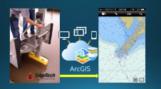
EdgeTech has entered into a cooperative engagement with Esri. Utilising Esri’s ArcGIS for Maritime platform in combination with the EdgeTech 6205 sonar, customers have access to real-time, high-resolution, three-dimensional (3D)...

Esri and the XPRIZE Foundation are partnering in the Shell Ocean Discovery XPRIZE. The cooperation will help accelerate innovative surveys of the ocean, 95% of which remains unexplored. Esri will...
There are vast applications for geographic information system (GIS) technology. Nowhere was this more apparent than the floors of the San Diego Convention Center, USA, during this year's annual Esri...
This site uses cookies. By continuing to use this website, you agree to our Cookies Policy. Agree