Welcome to the New Geospatial
Teledyne Optech and Teledyne CARIS have united to form Teledyne Geospatial in response to evolving marketplace needs. Under the Teledyne Imaging group, the harmony between the two business units is...
Teledyne Optech and Teledyne CARIS have united to form Teledyne Geospatial in response to evolving marketplace needs. Under the Teledyne Imaging group, the harmony between the two business units is...
Teledyne has announced the launch of a geospatial group with the unification of its Optech and CARIS businesses. The new Teledyne Geospatial group will offer holistic solutions to seamlessly map...
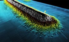
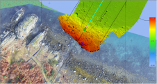
The combination of bathymetry and Lidar provides in-depth data and view of stream quality for aquatic resource managers in Tennessee, USA. Since its inception in 2015, Skytec has created data-driven...
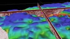
In 2021, five Norwegian and international companies decided to join forces to support the development of software that can be used to interpret seabed and subsurface ground conditions and visualize the results. The...
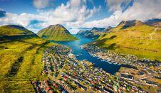
Crewless aerial mapping was recently chosen when surveying the Faroe Islands. For the small team, labour savings provided one advantage of a UAV-based approach. Another benefit was that clear skies...
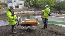
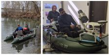
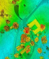
In early spring 2021, Storm Geomatics were approached by an existing client to carry out topographic and bathymetric surveys on the River Aire, in the village of Newlay, to the...
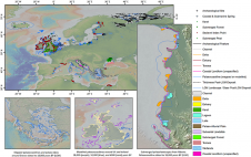
EMODnet Geology has updated the ‘Submerged Landscapes’ data product. This fully attributed GIS layer now comprises more than 16,000 features representing 27 classes of submerged landscape and palaeoenvironmental indicators, including...

Dr Gema Casal holds a degree in marine biology and a PhD on coastal remote sensing and GIS. She is interested in the application of remote sensing technologies, especially optical...
XOCEAN has completed 35 cable inspection surveys using a combination of uncrewed surface vessels (USVs) and uncrewed aerial vehicles (UAVs) between the Scottish mainland and Western Isles. There was a...
As the demand for elevation data continues to rise, it is important that users match the level of reliability, accuracy and resolution of the data to their specific application to...
This site uses cookies. By continuing to use this website, you agree to our Cookies Policy. Agree