First Uncrewed Vessel Seabed Survey in Irish Waters
In a first for Ireland, an Uncrewed Surface Vessel (USV) was launched by XOCEAN off County Louth in the last week of January 2022, to undertake an environmental survey of...
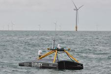
In a first for Ireland, an Uncrewed Surface Vessel (USV) was launched by XOCEAN off County Louth in the last week of January 2022, to undertake an environmental survey of...
As media partner, we are excited to share the brilliant news for the global ocean technology and hydrographic community that the Oceanology International (Oi) exhibition and conference is back on...
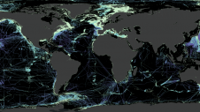
Over the last few centuries, mapping the ocean seabed has formed a major challenge for marine geoscientists. Ocean bathymetric charts and submarine geomorphology have significantly impacted our understanding of our...
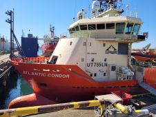
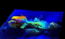
The key objective was to make a rapid and accurate determination of the source of the diesel and oil that had appeared on the ocean’s surface. The company carried out hydrographic survey work using a Norbit Winghead i77h multibeam echosounder (MBES) system. An oil slick was seen on the surface of Nootka Sound and staining on rocks of nearby Bligh Island, west of Vancouver Island, Canada, in late 2020. This set in...
Hydro International invited various leading experts with different professional backgrounds to share their thoughts on the present and future of the hydrographic industry. In this interview, Commodore Stewart Dunne, Hydrographer...
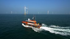
The shift towards an economy based on renewable energy and growing efforts to enhance nautical charting are two driving forces in the hydrographic industry, and the business will increasingly turn...

Workplaces that foster equity, diversity and inclusion are not simply ‘doing the right thing’: they also benefit from the ensuing diversity of perspectives and increase their talent pool and economic...
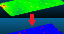
Poor visibility conditions have a huge impact on the environmental perception of autonomous robots. How can they still operate safely and reliably? In the new DeeperSense project, an international consortium...
While online data acquisition is of course of the utmost importance in hydrography, technological developments mean that modern surveyors also need to know about data science, machine learning and artificial...
For centuries, the Goodwin Sands – a 16km-long sandbank at the southern end of the North Sea off the coast of Kent, England – have posed a navigational threat to...
This site uses cookies. By continuing to use this website, you agree to our Cookies Policy. Agree