Introducing the Denmark Depth Model
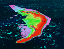
The Denmark Depth Model (DDM) is a digital bathymetric model covering Denmark’s exclusive economic zone (EEZ). It was developed based on hundreds of bathymetric survey datasets and historical sources and...
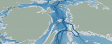
The Denmark Depth Model (DDM) is a digital bathymetric model covering Denmark’s exclusive economic zone (EEZ). It was developed based on hundreds of bathymetric survey datasets and historical sources and...
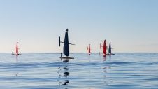
Saildrone, a company renowned for providing near real-time maritime intelligence using small unmanned systems, has introduced a new line of unmanned surface vehicles (USVs) in the mid-size category. The Voyager,...
GEOMOD is a software development company specialized in marine geomatics and hydrography. Since 2004, we have been building our expertise on hydrographic products dedicated to mariners, harbour workers, and hydrographic...
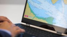
Cartographers working in hydrographic offices and ENC editors have the responsibility of processing bathymetry datasets to generate ENCs compliant with the S-57 IHO standard. This is a time-consuming and fastidious task that requires a specific set of skills and knowledge. Nowadays, this expertise is challenged by the constant progress being made in data acquisition techniques and equipment, which has led to a significant increase in the number and size of bathymetry datasets. To face these challenges, the CARTONAUT project was launched by Shom cartographers in collaboration with GEOMOD marine geomatics engineers, both located in Brest, France. The project led to the creation of CALHYPSO, an automated solution for the generalization of bathymetry datasets for S-57 ENC production. This article reports the development of CALHYPSO through the CARTONAUT project and provides details about the tool’s concept and features. Cartographers working in hydrographic offices and ENC editors have the responsibility of processing bathymetry datasets to generate ENCs compliant with the S-57 IHO standard. This is a time-consuming and fastidious...

MacArtney Underwater Technology and Textron Systems have partnered to supply custom-built winches for the US Navy’s Mine Countermeasures unmanned surface vehicle (MCM USV). MacArtney has drawn on its in-house expertise...
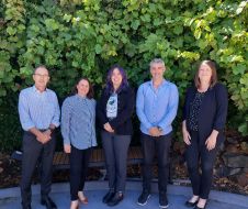
The Blue Economy Cooperative Research Centre (BE CRC) has entered into a new partnership with Echoview Software, the industry-leading hydroacoustic data processing science and software experts. Established in 2019, BE...
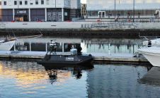
Maritime Robotics has been given permission to operate uncrewed surface vehicles (USVs) on the freight route between Trondheim and Vanvikan by the Norwegian Coastal Administration and the Norwegian Maritime Directorate....
TCarta Marine, a global provider of hydrospatial products and services, is expanding its involvement in the Seabed 2030 project. The initiative aims to map the entire ocean floor by 2030,...
The Nippon Foundation-GEBCO Seabed 2030 Project is seeking support for its collaborative initiative to map the world’s oceans by 2030 and compile all bathymetric data into the freely available GEBCO...
The UK Hydrographic Office (UKHO) has revised its plan to phase out the production of paper navigation charts. The original plan, announced in July 2022, was to end the production...
This site uses cookies. By continuing to use this website, you agree to our Cookies Policy. Agree