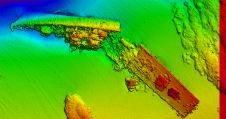
Site of 1910 Shipwreck off the Coast of Delaware Identified
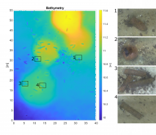
In 1910, the Navy steamer tug known as the USS Nina sank off the coast of Delaware and Maryland with more than 30 people aboard. Since that time, the official...
In 1910, the Navy steamer tug known as the USS Nina sank off the coast of Delaware and Maryland with more than 30 people aboard. Since that time, the official...
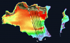
The Greater Montréal Area completed Canada’s largest-ever riverine topobathymetric Lidar survey in response to two major flooding events within the last five years, which together displaced tens of thousands of...
The UK Hydrographic Office (UKHO) will support maritime trade and economic growth in the Cayman Islands as it embarks on a new programme of seabed mapping surveys in November 2021,...
TCarta Marine, a global provider of hydrospatial products, will demonstrate the new Trident Satellite Derived Bathymetry (SDB) Toolbox, now available as a software-as-a-service product, at GEOINT 2021, which is being...
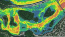
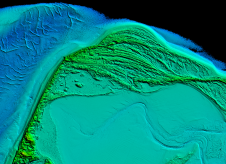
The combination of bathymetry and Lidar provides in-depth data and view of stream quality for aquatic resource managers in Tennessee, USA. Since its inception in 2015, Skytec has created data-driven...
Arctia-Meritaito has efficiently produced a seamless digital terrain model of land and water along the shallow coastal areas of the German island of Sylt, using a Leica Chiroptera 4X airborne...
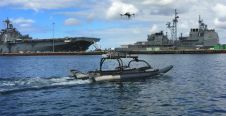
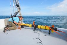
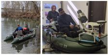
Marine Advanced Robotics and Planck Aerosystems have established a strategic alliance to provide a multi-domain robotic team that includes an unmanned surface vessel (USV) equipped with a small unmanned aircraft...
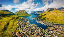
Crewless aerial mapping was recently chosen when surveying the Faroe Islands. For the small team, labour savings provided one advantage of a UAV-based approach. Another benefit was that clear skies...
The detection of unexploded ordnance (UXO) in the sea is a demanding task. UXO survey data is acquired using a set of different sensors in different configurations and can span...
Mapping shallow, nearshore areas can be a challenging job. The waters along coasts and islands are important to human activities, but when it comes to mapping these areas there is...
This site uses cookies. By continuing to use this website, you agree to our Cookies Policy. Agree