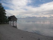
Navigating the rising tide
Experts are extremely concerned about the temperature of the Pacific Ocean, as the sea surface temperature this year was the warmest since satellite measurements began. This can have major consequences: for...
Experts are extremely concerned about the temperature of the Pacific Ocean, as the sea surface temperature this year was the warmest since satellite measurements began. This can have major consequences: for...

Starting in 2005, the French Naval Hydrographic and Oceanographic Office (Service hydrographique et océanographique de la marine [Shom]) and the French National Geographic Institute (Institut National de l’Information Géographique et...
A NEXUS 800 UAS powered by HYPACK has been provided to the US southeastern geospatial solutions company SurvTech. The company will use the device to acquire upland data simultaneous with...
From 23 October to 24 November, Hydro International will bring bathymetric sensor technology into the spotlight during the Bathymetric Sensor Weeks. These themed weeks will feature a dedicated weekly newsletter...

Geo-matching.com has announced the addition of a new category for Unmanned Aerial Systems. The types of Unmanned Aerial Systems (UAS) that qualify for inclusion in this new category are all...
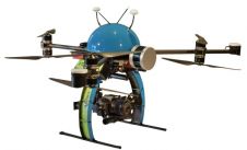
A new system for autonomous airborne hydrographic surveys has been launched by THURN Group. The THURN QuickDip system of data collection uses aerial drones to carry Valeport sensors on pre-planned...
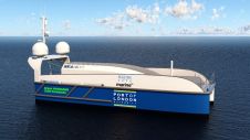
SEA-KIT International has won funding from the Zero Emissions Vessels and Infrastructure (ZEVI) competition to design and manufacture a hydrogen-fuelled uncrewed surface vessel (USV). The company will partner with maritime...

The Norwegian government recently announced comprehensive measures to combat the spread of the coronavirus, effective immediately. As a result, all travellers to Norway from non-Nordic countries who do not have...
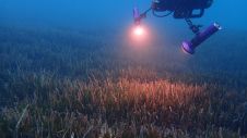
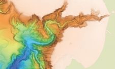
The ocean plays a crucial role in mitigating climate change, yet we lack detailed information on over 95% of the seafloor. This article explores planblue’s solution to accelerate time-to-data and...
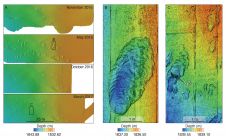
Cutting-edge technology has been utilized to survey Monterey Canyon’s seafloor by a research team comprising members from MBARI, USGS, Durham University, the University of Hull and Pontificia Universidad Católica de...
This site uses cookies. By continuing to use this website, you agree to our Cookies Policy. Agree