30 Years of Success
Dr Salem E. Masry, president and chief executive officer of CARIS, accepted to be interviewed by Hydro international on the occasion of the 30th anniversary of his enterprise. Dr Masry,...

Dr Salem E. Masry, president and chief executive officer of CARIS, accepted to be interviewed by Hydro international on the occasion of the 30th anniversary of his enterprise. Dr Masry,...
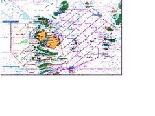
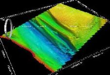
Amongst the largest contracted coastal hydrographic Lidar survey projects awarded in recent years is the Australian Hydrographic Service (AHS) survey of the Torres Strait in Northern Queensland. The intent of...
A first prototype of the new and ambitious European Marine Observation and Data Network (EMODnet) will be launched in 2010. Hydrographic data will be an integral part of this large...
Hydrographic data are usually characterised by their geospatial nature, with tremendous and huge amounts of information that are usually abundant but are not adequately maintained, managed and represented for effective...
The Autumn Symposium organised and hosted by the Southern Region of the Hydrographic Society UK was held on 27 October 2009 at Bradfield College, near Reading, and attracted an attendance...
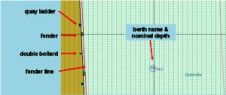
The management of larger vessels within the confined, shallow and/or tidal environments of ports requires precise chart information. However, current ECDIS and Inland ECDIS standards do not meet the more...
CARIS is to release Spatial Fusion Enterprise (SFE) 5.2 as part of its Ping-to-Chart product suite. SFE is Web-enabling technology for geospatial information that aims at leveraging the investment of...
During the CHC 2010 Conference, Caris is organising workshop on bathymetric data management utilizing relational database management systems (RDBMS). This workshop is free for registrants at the CHC but requires...
Esri expands the power of geoportals with the release of the ArcGIS Server 10 Geoportal extension. The extension allows organisations to quickly set up websites, called geoportals that help them...

The coastal zone is immensely important for humankind, marine and coastal spatial planning is a vital tool for planning and preserving the world’s coasts. Ron Furness, is a nautical cartographer,...
This site uses cookies. By continuing to use this website, you agree to our Cookies Policy. Agree