Editorial
Geohazards (geological features or processes) can be a risk to oil and gas infrastructure, and to the environment. Landslides, fault ruptures, gas/fluid expulsions, adverse soil conditions and iceberg scouring, to...
Geohazards (geological features or processes) can be a risk to oil and gas infrastructure, and to the environment. Landslides, fault ruptures, gas/fluid expulsions, adverse soil conditions and iceberg scouring, to...
An electronic chart service designed to ease paper chart users into the digital age will be showcased by the UK Hydrographic Office (UKHO) at the Marintec China show. The Admiralty...
JNCC has launched the new MESH website. The site has been enlarged and completely redesigned to reflect the enormous number and range of products that the project has generated over...
Hydrography and defence have had a peculiar relationship over the centuries. On the one hand, the possession of good nautical charts and other information gave predominance over the enemy and...
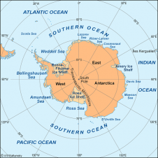
The Scientific Committee on Antarctic Research (SCAR) expert group for the compilation of the new International Bathymetric Chart of the Southern Ocean (IBCSO) proposes to build a consistent bathymetric database...
Safe Software has granted official "FME Certified" accreditation to FME experts from around the world. These individuals are the first to be formally assessed and recognised as part of a...
Safe Softwar's FME spatial ETL (extract, transform, and load) platform will support the spatial data capabilities made available in the SQL Server 2008 November Community Technology Preview (CTP). In the...
Trimble has received a contract from the U.S. Coast Guard (USCG) to provide up to 400 reference station receivers over the next three years for its Maritime Differential GPS (DGPS)...
As most readers will know, the United Nations Convention on the Law of the Sea (UNCLOS) stipulates that information on the limits of the continental shelf beyond 200 nautical miles...

In July 2007, a hydrographic survey team from Duck (NC, USA) mapped 6.7 square miles of the Currituck Sound in water depths of less than 3m. The aim was to...
This site uses cookies. By continuing to use this website, you agree to our Cookies Policy. Agree