Found 96 results
Sort by

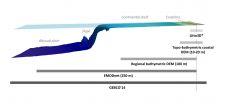
Marine Asset Integrity Mapping

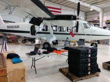
Advances in marine & terrestrial scanning survey techniques together with precise inertial navigation sensors, multi-sensor acquisition systems and cost-effective UAS photogrammetry allow hydrographic surveyors to undertake high-precision marine asset integrity...

Read more

Coastal Risk Assessment

SHOM contributes routinely to the preparedness against coastal risks along French coastlines. For this purpose, regional to coastal digital elevation models are built for implementation in forecast systems against rapid...

Read more

Surveying Japanese Inland and Coastal Waters

In March 2015, Leica Geosystems conducted a series of demonstration surveys in Japan with the HawkEye III Airborne Topographic Bathymetric Lidar system. This demonstration was designed to prove the depth performance...

Read more

FLiDAR Acquired by AXYS Technologies

AXYS Technologies has signed a definitive agreement to acquire 100% of the FLiDAR shares. Together, AXYS and FLiDAR will be a leading supplier of floating Lidar systems worldwide. AXYS has...

Read more

Oceans of Colour

Natural water colour measurements are based on multi- and hyper-spectral measurements performed in the field and from space. A simpler approach to determine the colour of natural waters is by...

Read more