Guy Rigot
Guy Rigot is chief technology officer and co-founder of planblue. Before planblue, he worked on the Attitude and Orbit Control System (AOCS) of the MeteoSat Third Generation (MTG) satellite and...

Guy Rigot is chief technology officer and co-founder of planblue. Before planblue, he worked on the Attitude and Orbit Control System (AOCS) of the MeteoSat Third Generation (MTG) satellite and...
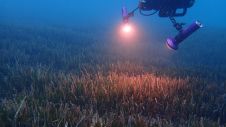
The ocean plays a crucial role in mitigating climate change, yet we lack detailed information on over 95% of the seafloor. This article explores planblue’s solution to accelerate time-to-data and...
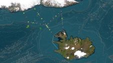
The University of Barcelona is leading an expedition to investigate the world’s largest waterfall, which is actually located underwater between Iceland and Greenland. Although the physical oceanography has been extensively...

Renewable energy and the pivotal role of hydrography in offshore development take centre stage in a captivating interview with Professor Ed Hill, chief executive of the National Oceanography Centre (NOC)....
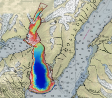
Alaska’s history of devastating landslides and tsunamis creates challenges in assessing communities’ risk without water depth data at the base of unstable slopes. To address this, the US Geological Survey...
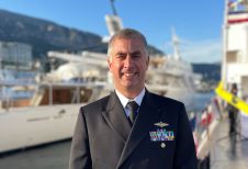
Hydro International interviewed RDML Benjamin Evans, director of NOAA’s Office of Coast Survey. Evans is responsible for overseeing the mapping and charting of all US coastal waters, as well as...
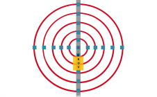
Underwater positioning with USBL can be accurate in favourable environments. However, it’s often perceived as less precise than land-based positioning. Maintaining high accuracy during mobilization and calibration is crucial. If...
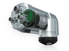
Exail, a global leader in high-performance subsea inertial navigation systems (INS), recently launched the Rovins 9 DVL, an innovative all-in-one system that combines the strengths of inertial navigation and Doppler...
In many places around the world, data clearly shows a rise in sea level. In low-lying coastal areas, even small increases when coupled with high tides and storm surges can...

Seabed 2030 is rapidly approaching its ultimate objective of mapping the entire seabed within seven years. To achieve this goal, the project is actively seeking donations of both public and...
This site uses cookies. By continuing to use this website, you agree to our Cookies Policy. Agree