Preparing for sea-level rise thanks to hydrography
In many places around the world, data clearly shows a rise in sea level. In low-lying coastal areas, even small increases when coupled with high tides and storm surges can...
In many places around the world, data clearly shows a rise in sea level. In low-lying coastal areas, even small increases when coupled with high tides and storm surges can...
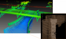
A decade after completing its first shoreline mapping project, NV5 Geospatial has mapped over 10.5 million hectares of North America’s shoreline and riverine environments for more than 200 projects. These...
The implementation of the new IHO hydrographic geospatial standard for marine data and information, the S-100 product family, presents significant challenges that require coordination between the IHO, the industry involved...

Charles de Jongh holds an MSc in cartography and geographical information science. He has 20 years of experience in the marine geospatial field, including several roles at software company CARIS...
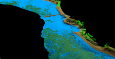
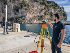
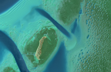
As part of a Catalan government project to improve the management of its marine environment, ICGC cooperated with Field to use airborne Lidar bathymetry (ALB) to survey the Catalan coastal...
Teledyne Geospatial will bring its latest advancements in ocean mapping hardware and software solutions to Ocean Business 2023, being held at the National Oceanography Centre, Southampton, UK from April 18-20....
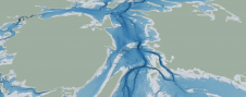
The Denmark Depth Model (DDM) is a digital bathymetric model covering Denmark’s exclusive economic zone (EEZ). It was developed based on hundreds of bathymetric survey datasets and historical sources and...

Much remains unknown about the benthic ecosystem that the blue economy depends on, and improved benthic habitat mapping is key to the sustainable development of the blue economy. While remote...

The impacts of climate change and sea-level rise on daily life in Kiribati and the Pacific region can also be felt in the hydrographic profession. In this interview, Tion Uriam,...

Terradepth, a leading provider of ocean data solutions, has been selected to participate in the World Economic Forum’s (WEF) prestigious Ocean Data Challenge, a programme aimed at enhancing sustainable ocean...
This site uses cookies. By continuing to use this website, you agree to our Cookies Policy. Agree