Seabed 2030: The Final Sprint
The Nippon Foundation-GEBCO Seabed 2030 Project has just over nine years left to achieve its indispensable goal of the definitive, freely available map of the entire world ocean floor. The Project’s...
Find the hydrographical article you are looking for: filter by article type such as interviews, editorials and features, or filter by date or subject. You can also search the entire Hydro International article archive.
The Nippon Foundation-GEBCO Seabed 2030 Project has just over nine years left to achieve its indispensable goal of the definitive, freely available map of the entire world ocean floor. The Project’s...
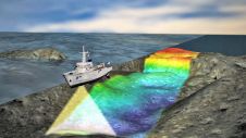
The multibeam echosounder (MBES) is used for various purposes, and MBES systems have become the standard instrument for bathymetric determination. However, new developments mean that MBES systems are ...

Machine learning is currently experiencing a surge of interest. Of course, what first come to mind are self-driving cars, face recognition and internet algorithms. However, while these are great examp...

Mathias Jonas, Secretary-General, IHO, describes the implications of the UN Decade of Ocean Science for Sustainable Development for the IHO and the hydrography sector. Proclaimed in 2017 by the United...
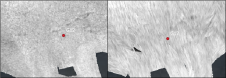
In November 2020, a team of researchers from GEOMAR and EGEOS embarked on an unusual round trip across the German Baltic Sea. Their mission was to shed light on the little-known post-war legacy of mun...
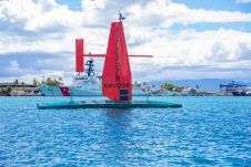
SHOM – the French national hydrographic service – is planning to replace most of its aging seagoing assets in the near future and, in this context, a four-week sea trial took place in Brest, on th...
As the informed readership of Hydro International knows, the oceans sustain the planet. And, while there are many drivers of the changes to the Earth’s climate that now pose an existential threat to...
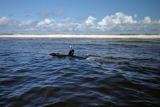
To achieve the aggressive goals of Seabed 2030, uncrewed survey systems must be used to augment more traditional ocean mapping efforts, particularly on the high seas. In addition to providing a much-n...
The South African Council for Geoscience recently launched an initiative to optimize marine geophysical data collection in South African waters. The main aim of the initiative is to produce marine off...
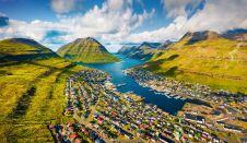
Crewless aerial mapping was recently chosen when surveying the Faroe Islands. For the small team, labour savings provided one advantage of a UAV-based approach. Another benefit was that clear skies ar...
Hydro International offers professionals the opportunity to contribute to any forthcoming issue in a practical and informative way, taking the editorial theme into account.
The editorial calendar can be downloaded here.
If you want to contribute, please contact Wim van Wegen, Content Manager of Hydro International.
Contact information
Wim van Wegen
[email protected]
+31 (0)514 561854
This site uses cookies. By continuing to use this website, you agree to our Cookies Policy. Agree