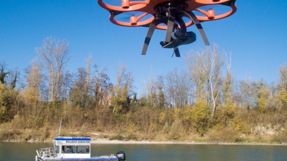
Unmanned Mapping of Ultra-shallow Waters
Hydrographic surveying in ultra-shallow, inland and enclosed waters can prove extremely challenging and often presents increased risks and obstacles to both personnel and equipment...
Every month we will focus on a specific theme, featuring a selection of articles which have previously been published in Hydro International magazine. By including a mix of older and more recent articles, we will present a complete recap of the subject. Furthermore, we will be bringing you a bi-weekly round-up of ‘Focus Stories’ related to the theme through our newsletter (sign up here). The theme for September 2017 is:
Even when for inland water mapping the hydrographic techniques are familar, there are special requirements and challenges often due to the specific characteristics of inland survey and positioning. Often it's related to the reduced depth, accessibility or working space. This also creates opportunities to use techniques like airborne Lidar bathymetry or USVs.
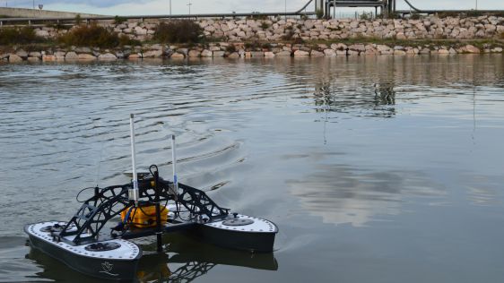
Hydrographic surveying in ultra-shallow, inland and enclosed waters can prove extremely challenging and often presents increased risks and obstacles to both personnel and equipment...
Seaports, waterways and climate are inextricably linked. Weather anomalies change bottom contours and destroy aids to navigation, compromising safety. In the past decade, maritime...
In March 2015, Leica Geosystems conducted a series of demonstration surveys in Japan with the HawkEye III Airborne Topographic Bathymetric Lidar system. This demonstration was...
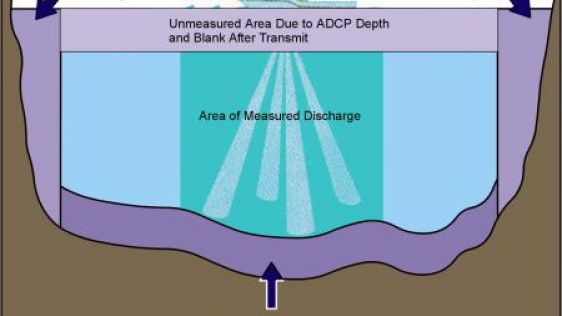
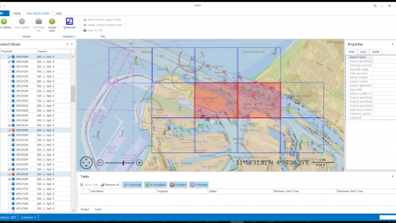
There is a key new feature in the discharge measurement software ViSea DAS that allows the user to add a bottom profile. By doing so, side extrapolation from the start and end poin...
Every month we will focus on a specific theme, featuring a selection of articles which have previously been published in Hydro International magazine. to present a complete recap of the subject. If you don't want to miss these themed recaps, sign up for the newsletter (sign up here).
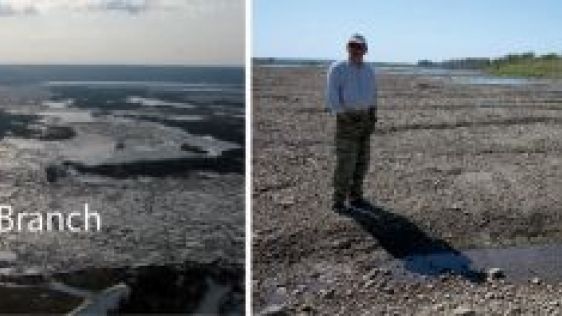
The large, poleward flowing rivers of Siberia, such as the Ob River, experience persistent and severe floods when river ice breaks up in the spring. Ice-jams are common on the Tom...
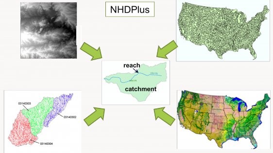
Land surface hydrography now supports the modelling of continental-scale streamflow at high resolution and in near real time. The US National Hydrography Dataset contains about 2.7...
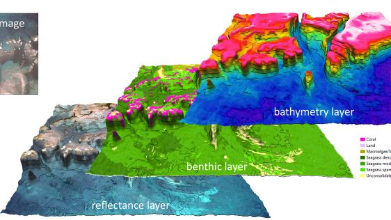
A recent article provides an overview of satellite-derived bathymetry methods and how data can be integrated into survey campaigns, and showcases three use cases. Bathymetric data...
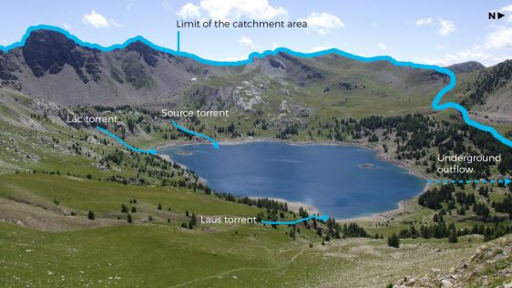
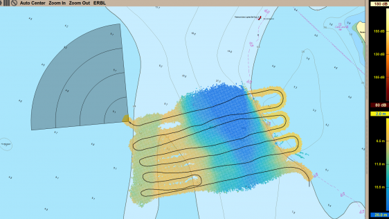
The need for lake & river surveys constantly increases as human activity expands in these areas. While navigation remains a main focus, nowadays other applications such as hydr...
The Port of Rotterdam is a leading global port and by far the largest seaport in Europe. The port is situated in the Rhine delta and with its direct connection to Europe’s la...
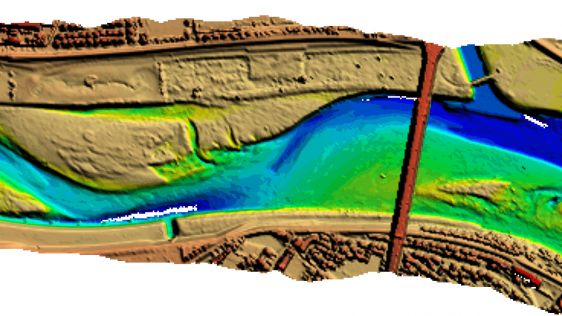
Knowing the volume of material present in a gravel quarry can make the difference between profit and loss. A gravel quarry in Hartheim am Rhein, southwest Germany, is partially cov...
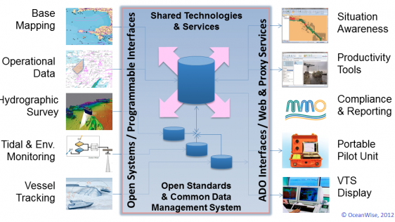
Ports require access to a wide range of data and information to function safely and efficiently. Some of that data is acquired from external stakeholders but most is generated inte...

False Pass, AK, USA, is the eastern-most passage through the Aleutian Islands between the Bering Sea and the Pacific Ocean and provides a passage for small to mid-size vessels. The...

For the fifth year in a row, the Lake Survey was held in the Netherlands. This year Teledyne CARIS collaborated with Boskalis and Fugro in a one-week all-encompassing practical sur...
In his column in 'Hydro International', Mark Sinclair from Fugro writes that he commends the ‘Technology in Focus: Bathymetric Lidar’ article; it is righ...
Follow Hydro International on Facebook, LinkedIn, Twitter or sign up for the newsletter! Don't miss the latest developments: join Hydro International!
 |  |  |  |
| 14.540 SUBSCRIBERS | 7.245 MEMBERS | 5.205 LIKES | 4.632 |
This site uses cookies. By continuing to use this website, you agree to our Cookies Policy. Agree